Manasota Key geodata
Manasota Key (Florida) is a populated place; located in United States in America/New_York (GMT-4) time zone. With population of 1,229 people, there are 14963 cities with bigger population in this country. Compared to other cities in United States, 97.7% of cities are located further ↑North; 64.5% of cities are located further ←West and 99.6% of cities have higher elevation than Manasota Key. Note1


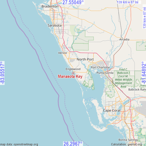
Manasota Key GPS coordinates[2]
26° 55' 31.224" North, 82° 21' 7.344" West
| Map corner | latitude | longitude |
|---|---|---|
| Upper-left | 27.55049°, | -83.05517° |
| Center: | 26.92534°, | -82.35204° |
| Lower-right: | 26.2967°, | -81.64892° |
| Map W x H: | 139.4×139.4 km | = 86.6×86.6mi |
| max Lat: | 71.29058° ⇑97.7% North |
| Manasota Key: | 26.92534° |
| min Lat: | ⇓2.3% South 19.06759° |
| min Long | Manasota Key | max Long |
| -171.73463° | -82.35204° | -66.98998° |
| W 64.5%⇐ | ⇒35.5% E |
Elevation
Elevation of Manasota Key is 1 m = 3 ft, and this is 293.8 m = 964 ft below average elevation for this country.
| Max E: |
3189 m = 10463 ft | 99.6% |
| Avg. | 294.8 m = 967 ft | |
| Manasota Key | 1 m = 3 ft | |
Min E: |
-60 m = -197 ft | 0.4% |
See also: United States elevation on elevation.city.
Geographical zone
Manasota Key is located in North temperate zone (between Tropic of Cancer and the Arctic Circle). Distance of this Northern Tropic circle is 387.9 km =241 mi to South.| Distance of | km | miles | from Manasota Key |
|---|---|---|---|
| North Pole | 7013.2 | 4357.8 | to North |
| Arctic Circle | 4407.4 | 2738.6 | to North |
| Tropic Cancer | 387.9 | 241 | to South |
| Equator | 2993.8 | 1860.3 | to South |


Nearby cities:
15 places around Manasota Key: (largest is in red/bold)
• Charlotte Harbor
28.5 km =17.7 mi,  82°
82°
• Charlotte Park
29.6 km =18.4 mi,  93°
93°
• Englewood
4.1 km =2.5 mi,  359°
359°
• Grove City
2.8 km =1.7 mi,  116°
116°
• Laurel
26.6 km =16.5 mi,  335°
335°
• Nokomis
23.4 km =14.5 mi, 337°
• North Port
17.5 km =10.9 mi,  41°
41°
• Plantation
16 km =9.9 mi,  352°
352°
• Port Charlotte
26.5 km =16.5 mi, 77°
• Punta Gorda Isles
27.1 km =16.8 mi, 91°
• Rotonda West
7.7 km =4.8 mi,  127°
127°
• South Venice
15.9 km =9.9 mi,  333°
333°
• Venice
21.9 km =13.6 mi, 332°
• Venice Gardens
17.3 km =10.7 mi, 341°
• Warm Mineral Springs
17.5 km =10.9 mi,  31°
31°
Sources, notices
• [Note1] Compared only with cities in United States existing in our database
• [Src1] Map data: © OpenStreetMap contributors (CC-BY-SA)
• [Src2] Other city data from geonames.org with taken over terms of usage.
• [Src3] Geographical zone / Annual Mean Temperature by Robert A. Rohde @ Wikipedia
