Naples geodata
Naples (Florida) is a seat of a second-order administrative division; located in United States in America/New_York (GMT-4) time zone. With population of 21,512 people, there are 2349 cities with bigger population in this country. Compared to other cities in United States, 98.6% of cities are located further ↑North; 66.3% of cities are located further ←West and 96.6% of cities have higher elevation than Naples. Note1


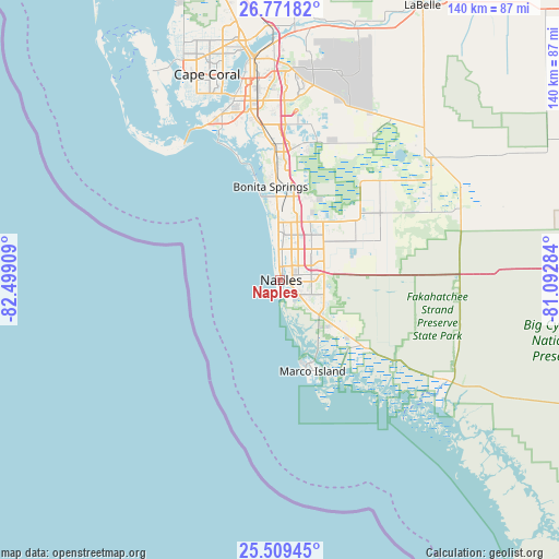
Naples GPS coordinates[2]
26° 8' 32.424" North, 81° 47' 45.456" West
| Map corner | latitude | longitude |
|---|---|---|
| Upper-left | 26.77182°, | -82.49909° |
| Center: | 26.14234°, | -81.79596° |
| Lower-right: | 25.50945°, | -81.09284° |
| Map W x H: | 140.4×140.4 km | = 87.2×87.2mi |
| max Lat: | 71.29058° ⇑98.6% North |
| Naples: | 26.14234° |
| min Lat: | ⇓1.4% South 19.06759° |
| min Long | Naples | max Long |
| -171.73463° | -81.79596° | -66.98998° |
| W 66.3%⇐ | ⇒33.7% E |
Elevation
Elevation of Naples is 7 m = 23 ft, and this is 287.8 m = 944 ft below average elevation for this country.
| Max E: |
3189 m = 10463 ft | 96.6% |
| Avg. | 294.8 m = 967 ft | |
| Naples | 7 m = 23 ft | |
Min E: |
-60 m = -197 ft | 3.4% |
See also: United States elevation on elevation.city.
Geographical zone
Naples is located in North temperate zone (between Tropic of Cancer and the Arctic Circle). Distance of this Northern Tropic circle is 300.8 km =186.9 mi to South.| Distance of | km | miles | from Naples |
|---|---|---|---|
| North Pole | 7100.3 | 4411.9 | to North |
| Arctic Circle | 4494.4 | 2792.7 | to North |
| Tropic Cancer | 300.8 | 186.9 | to South |
| Equator | 2906.8 | 1806.2 | to South |


Nearby cities:
15 places around Naples: (largest is in red/bold)
• Bonita Springs
22 km =13.7 mi,  4°
4°
• East Naples
3 km =1.9 mi,  98°
98°
• Golden Gate
11.3 km =7 mi,  63°
63°
• Island Walk
14.8 km =9.2 mi,  35°
35°
• Lely
8.2 km =5.1 mi,  124°
124°
• Lely Resort
11.9 km =7.4 mi, 124°
• Marco
20 km =12.4 mi,  160°
160°
• Marco Island
23.7 km =14.7 mi, 160°
• Naples Manor
9.2 km =5.7 mi,  130°
130°
• Naples Park
13.3 km =8.3 mi,  354°
354°
• Orangetree
26.6 km =16.5 mi,  51°
51°
• Pelican Bay
9.9 km =6.2 mi, 354°
• Pine Ridge
9.8 km =6.1 mi, 0°
• Verona Walk
13.3 km =8.3 mi, 119°
• Vineyards
11.3 km =7 mi, 36°
Sources, notices
• [Note1] Compared only with cities in United States existing in our database
• [Src1] Map data: © OpenStreetMap contributors (CC-BY-SA)
• [Src2] Other city data from geonames.org with taken over terms of usage.
• [Src3] Geographical zone / Annual Mean Temperature by Robert A. Rohde @ Wikipedia
