Opa-locka geodata
Opa-locka (Florida) is a populated place; located in United States in America/New_York (GMT-4) time zone. With population of 16,565 people, there are 2965 cities with bigger population in this country. Compared to other cities in United States, 99% of cities are located further ↑North; 71.9% of cities are located further ←West and 94.8% of cities have higher elevation than Opa-locka. Note1


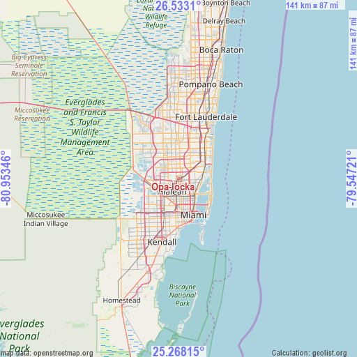
Opa-locka GPS coordinates[2]
25° 54' 8.352" North, 80° 15' 1.188" West
| Map corner | latitude | longitude |
|---|---|---|
| Upper-left | 26.5331°, | -80.95346° |
| Center: | 25.90232°, | -80.25033° |
| Lower-right: | 25.26815°, | -79.54721° |
| Map W x H: | 140.6×140.7 km | = 87.4×87.4mi |
| max Lat: | 71.29058° ⇑99% North |
| Opa-locka: | 25.90232° |
| min Lat: | ⇓1% South 19.06759° |
| min Long | Opa-locka | max Long |
| -171.73463° | -80.25033° | -66.98998° |
| W 71.9%⇐ | ⇒28.1% E |
Elevation
Elevation of Opa-locka is 9 m = 30 ft, and this is 285.8 m = 938 ft below average elevation for this country.
| Max E: |
3189 m = 10463 ft | 94.8% |
| Avg. | 294.8 m = 967 ft | |
| Opa-locka | 9 m = 30 ft | |
Min E: |
-60 m = -197 ft | 5.2% |
See also: United States elevation on elevation.city.
Geographical zone
Opa-locka is located in North temperate zone (between Tropic of Cancer and the Arctic Circle). Distance of this Northern Tropic circle is 274.1 km =170.3 mi to South.| Distance of | km | miles | from Opa-locka |
|---|---|---|---|
| North Pole | 7127 | 4428.5 | to North |
| Arctic Circle | 4521.1 | 2809.3 | to North |
| Tropic Cancer | 274.1 | 170.3 | to South |
| Equator | 2880.1 | 1789.6 | to South |


Nearby cities:
15 places around Opa-locka: (largest is in red/bold)
• Bunche Park
2.4 km =1.5 mi,  33°
33°
• Carol City
4.3 km =2.7 mi,  6°
6°
• Gladeview
7.2 km =4.5 mi,  168°
168°
• Golden Glades
5.1 km =3.2 mi,  78°
78°
• Hialeah
5.7 km =3.5 mi,  209°
209°
• Lake Lucerne
7 km =4.3 mi, 7°
• Miami Gardens
4.4 km =2.7 mi, 6°
• Miami Lakes
5.9 km =3.7 mi,  276°
276°
• Miami Shores
7.2 km =4.5 mi,  127°
127°
• Norland
6.4 km =4 mi,  36°
36°
• North Miami
6.5 km =4 mi,  102°
102°
• Pinewood
5 km =3.1 mi,  138°
138°
• Scott Lake
4.7 km =2.9 mi,  22°
22°
• West Little River
5.2 km =3.2 mi, 165°
• Westview
2.4 km =1.5 mi,  159°
159°
Sources, notices
• [Note1] Compared only with cities in United States existing in our database
• [Src1] Map data: © OpenStreetMap contributors (CC-BY-SA)
• [Src2] Other city data from geonames.org with taken over terms of usage.
• [Src3] Geographical zone / Annual Mean Temperature by Robert A. Rohde @ Wikipedia
