Pensacola geodata
Pensacola (Florida) is a seat of a second-order administrative division; located in United States in America/Chicago (GMT-5) time zone. With population of 53,193 people, there are 877 cities with bigger population in this country. Compared to other cities in United States, 92.1% of cities are located further ↑North; 50.2% of cities are located further →East and 86.6% of cities have higher elevation than Pensacola. Note1


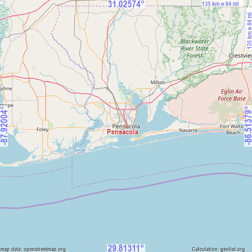
Pensacola GPS coordinates[2]
30° 25' 16.716" North, 87° 13' 0.876" West
| Map corner | latitude | longitude |
|---|---|---|
| Upper-left | 31.02574°, | -87.92004° |
| Center: | 30.42131°, | -87.21691° |
| Lower-right: | 29.81311°, | -86.51379° |
| Map W x H: | 134.8×134.8 km | = 83.8×83.8mi |
| max Lat: | 71.29058° ⇑92.1% North |
| Pensacola: | 30.42131° |
| min Lat: | ⇓7.9% South 19.06759° |
| min Long | Pensacola | max Long |
| -171.73463° | -87.21691° | -66.98998° |
| W 49.8%⇐ | ⇒50.2% E |
Elevation
Elevation of Pensacola is 24 m = 79 ft, and this is 270.8 m = 888 ft below average elevation for this country.
| Max E: |
3189 m = 10463 ft | 86.6% |
| Avg. | 294.8 m = 967 ft | |
| Pensacola | 24 m = 79 ft | |
Min E: |
-60 m = -197 ft | 13.4% |
See also: Pensacola elevation on elevation.city.
Geographical zone
Pensacola is located in North temperate zone (between Tropic of Cancer and the Arctic Circle). Distance of this Northern Tropic circle is 776.6 km =482.6 mi to South.| Distance of | km | miles | from Pensacola |
|---|---|---|---|
| North Pole | 6624.5 | 4116.3 | to North |
| Arctic Circle | 4018.6 | 2497 | to North |
| Tropic Cancer | 776.6 | 482.6 | to South |
| Equator | 3382.5 | 2101.8 | to South |


Nearby cities:
15 places around Pensacola: (largest is in red/bold)
• Bellview
10.4 km =6.5 mi,  295°
295°
• Brent
5.6 km =3.5 mi,  340°
340°
• East Pensacola Heights
3.6 km =2.2 mi,  76°
76°
• Ensley
12.1 km =7.5 mi,  333°
333°
• Ferry Pass
9.9 km =6.2 mi,  2°
2°
• Gonzalez
19.2 km =11.9 mi, 338°
• Goulding
2.5 km =1.6 mi,  347°
347°
• Gulf Breeze
8.8 km =5.5 mi,  144°
144°
• Midway
20.3 km =12.6 mi,  94°
94°
• Myrtle Grove
8.7 km =5.4 mi,  269°
269°
• Oriole Beach
13.1 km =8.1 mi,  113°
113°
• Pace
20.5 km =12.7 mi,  15°
15°
• Tiger Point
16.2 km =10.1 mi, 107°
• Warrington
6.9 km =4.3 mi,  233°
233°
• West Pensacola
6 km =3.7 mi,  275°
275°
Sources, notices
• [Note1] Compared only with cities in United States existing in our database
• [Src1] Map data: © OpenStreetMap contributors (CC-BY-SA)
• [Src2] Other city data from geonames.org with taken over terms of usage.
• [Src3] Geographical zone / Annual Mean Temperature by Robert A. Rohde @ Wikipedia
