Port LaBelle geodata
Port LaBelle (Florida) is a populated place; located in United States in America/New_York (GMT-4) time zone. With population of 3,530 people, there are 8829 cities with bigger population in this country. Compared to other cities in United States, 97.8% of cities are located further ↑North; 68.1% of cities are located further ←West and 96.6% of cities have higher elevation than Port LaBelle. Note1


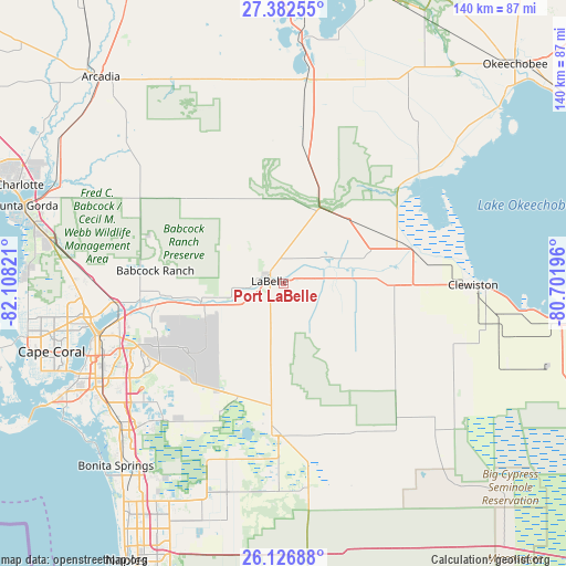
Port LaBelle GPS coordinates[2]
26° 45' 23.22" North, 81° 24' 18.288" West
| Map corner | latitude | longitude |
|---|---|---|
| Upper-left | 27.38255°, | -82.10821° |
| Center: | 26.75645°, | -81.40508° |
| Lower-right: | 26.12688°, | -80.70196° |
| Map W x H: | 139.6×139.6 km | = 86.7×86.7mi |
| max Lat: | 71.29058° ⇑97.8% North |
| Port LaBelle: | 26.75645° |
| min Lat: | ⇓2.2% South 19.06759° |
| min Long | Port LaBelle | max Long |
| -171.73463° | -81.40508° | -66.98998° |
| W 68.1%⇐ | ⇒31.9% E |
Elevation
Elevation of Port LaBelle is 7 m = 23 ft, and this is 287.8 m = 944 ft below average elevation for this country.
| Max E: |
3189 m = 10463 ft | 96.6% |
| Avg. | 294.8 m = 967 ft | |
| Port LaBelle | 7 m = 23 ft | |
Min E: |
-60 m = -197 ft | 3.4% |
See also: United States elevation on elevation.city.
Geographical zone
Port LaBelle is located in North temperate zone (between Tropic of Cancer and the Arctic Circle). Distance of this Northern Tropic circle is 369.1 km =229.3 mi to South.| Distance of | km | miles | from Port LaBelle |
|---|---|---|---|
| North Pole | 7032 | 4369.5 | to North |
| Arctic Circle | 4426.1 | 2750.3 | to North |
| Tropic Cancer | 369.1 | 229.3 | to South |
| Equator | 2975 | 1848.6 | to South |


Nearby cities:
15 places around Port LaBelle: (largest is in red/bold)
• Alva
20.9 km =13 mi,  257°
257°
• Buckingham
33.7 km =20.9 mi,  254°
254°
• Clewiston
46.8 km =29.1 mi,  90°
90°
• Fort Myers
45.8 km =28.5 mi, 250°
• Fort Myers Shores
34.3 km =21.3 mi, 261°
• Gateway
39.7 km =24.7 mi,  239°
239°
• Harlem
45.1 km =28 mi, 92°
• Immokalee
37.6 km =23.4 mi,  181°
181°
• LaBelle
3.4 km =2.1 mi,  280°
280°
• Lehigh Acres
26.2 km =16.3 mi, 236°
• Moore Haven
32.1 km =19.9 mi,  74°
74°
• North Fort Myers
48.2 km =30 mi, 258°
• Olga
30.8 km =19.1 mi, 262°
• Suncoast Estates
46.3 km =28.8 mi, 263°
• Tice
41.7 km =25.9 mi, 257°
Sources, notices
• [Note1] Compared only with cities in United States existing in our database
• [Src1] Map data: © OpenStreetMap contributors (CC-BY-SA)
• [Src2] Other city data from geonames.org with taken over terms of usage.
• [Src3] Geographical zone / Annual Mean Temperature by Robert A. Rohde @ Wikipedia
