Tamarac geodata
Tamarac (Florida) is a populated place; located in United States in America/New_York (GMT-4) time zone. With population of 64,681 people, there are 669 cities with bigger population in this country. Compared to other cities in United States, 98.5% of cities are located further ↑North; 71.9% of cities are located further ←West and 95.7% of cities have higher elevation than Tamarac. Note1


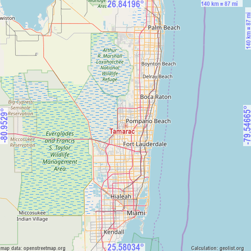
Tamarac GPS coordinates[2]
26° 12' 46.296" North, 80° 14' 59.172" West
| Map corner | latitude | longitude |
|---|---|---|
| Upper-left | 26.84196°, | -80.9529° |
| Center: | 26.21286°, | -80.24977° |
| Lower-right: | 25.58034°, | -79.54665° |
| Map W x H: | 140.3×140.3 km | = 87.2×87.2mi |
| max Lat: | 71.29058° ⇑98.5% North |
| Tamarac: | 26.21286° |
| min Lat: | ⇓1.5% South 19.06759° |
| min Long | Tamarac | max Long |
| -171.73463° | -80.24977° | -66.98998° |
| W 71.9%⇐ | ⇒28.1% E |
Elevation
Elevation of Tamarac is 8 m = 26 ft, and this is 286.8 m = 941 ft below average elevation for this country.
| Max E: |
3189 m = 10463 ft | 95.7% |
| Avg. | 294.8 m = 967 ft | |
| Tamarac | 8 m = 26 ft | |
Min E: |
-60 m = -197 ft | 4.3% |
See also: Tamarac elevation on elevation.city.
Geographical zone
Tamarac is located in North temperate zone (between Tropic of Cancer and the Arctic Circle). Distance of this Northern Tropic circle is 308.7 km =191.8 mi to South.| Distance of | km | miles | from Tamarac |
|---|---|---|---|
| North Pole | 7092.5 | 4407.1 | to North |
| Arctic Circle | 4486.6 | 2787.8 | to North |
| Tropic Cancer | 308.7 | 191.8 | to South |
| Equator | 2914.6 | 1811 | to South |


Nearby cities:
15 places around Tamarac: (largest is in red/bold)
• Broward Estates
11.2 km =7 mi,  149°
149°
• Coconut Creek
8.3 km =5.2 mi,  58°
58°
• Coral Springs
6.8 km =4.2 mi,  342°
342°
• Lauderdale Lakes
6.6 km =4.1 mi,  141°
141°
• Lauderhill
8.8 km =5.5 mi,  155°
155°
• Margate
5.6 km =3.5 mi,  50°
50°
• North Andrews Gardens
10.8 km =6.7 mi,  102°
102°
• North Lauderdale
2.4 km =1.5 mi,  78°
78°
• Palm Aire
5.8 km =3.6 mi, 97°
• Parkland
10.9 km =6.8 mi,  6°
6°
• Plantation
8.9 km =5.5 mi,  168°
168°
• Rock Island
9.7 km =6 mi,  131°
131°
• Roosevelt Gardens
10.6 km =6.6 mi, 139°
• Twin Lakes
9.6 km =6 mi,  111°
111°
• Washington Park
11.2 km =7 mi, 142°
Sources, notices
• [Note1] Compared only with cities in United States existing in our database
• [Src1] Map data: © OpenStreetMap contributors (CC-BY-SA)
• [Src2] Other city data from geonames.org with taken over terms of usage.
• [Src3] Geographical zone / Annual Mean Temperature by Robert A. Rohde @ Wikipedia
