Weeki Wachee Gardens geodata
Weeki Wachee Gardens (Florida) is a populated place; located in United States in America/New_York (GMT-4) time zone. With population of 1,146 people, there are 15402 cities with bigger population in this country. Compared to other cities in United States, 95.9% of cities are located further ↑North; 63.2% of cities are located further ←West and 93.9% of cities have higher elevation than Weeki Wachee Gardens. Note1
Current local time in Weeki Wachee Gardens:
03:57 AM, WednesdayDifference from your time zone: hours


Weeki Wachee Gardens GPS coordinates[2]
28° 32' 0.996" North, 82° 37' 46.344" West
| Map corner | latitude | longitude |
|---|---|---|
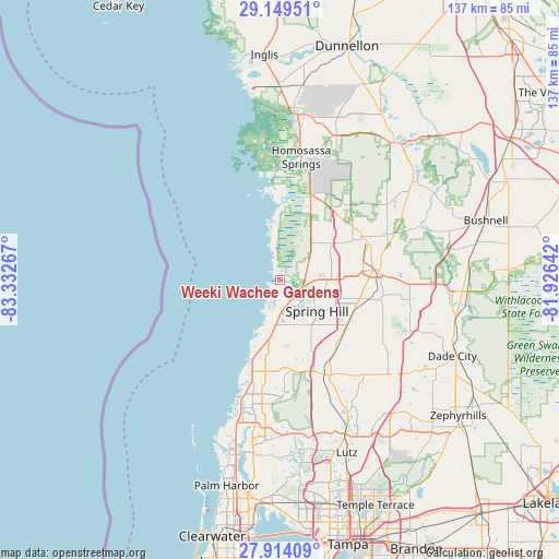
| Upper-left | 29.14951°, | -83.33267° |
| Center: | 28.53361°, | -82.62954° |
| Lower-right: | 27.91409°, | -81.92642° |
| Map W x H: | 137.4×137.4 km | = 85.4×85.4mi |
| max Lat: | 71.29058° ⇑95.9% North |
| Weeki Wachee Gardens: | 28.53361° |
| min Lat: | ⇓4.1% South 19.06759° |
| min Long | Weeki Wachee Ga | max Long |
| -171.73463° | -82.62954° | -66.98998° |
| W 63.2%⇐ | ⇒36.8% E |
Elevation
Elevation of Weeki Wachee Gardens is 10 m = 33 ft, and this is 284.8 m = 934 ft below average elevation for this country.
| Max E: |
3189 m = 10463 ft | 93.9% |
| Avg. | 294.8 m = 967 ft | |
| Weeki Wachee Gardens | 10 m = 33 ft | |
Min E: |
-60 m = -197 ft | 6.1% |
See also: United States elevation on elevation.city.
Geographical zone
Weeki Wachee Gardens is located in North temperate zone (between Tropic of Cancer and the Arctic Circle). Distance of this Northern Tropic circle is 566.7 km =352.1 mi to South.| Distance of | km | miles | from Weeki Wachee Gardens |
|---|---|---|---|
| North Pole | 6834.4 | 4246.7 | to North |
| Arctic Circle | 4228.5 | 2627.5 | to North |
| Tropic Cancer | 566.7 | 352.1 | to South |
| Equator | 3172.6 | 1971.4 | to South |


Nearby cities:
15 places around Weeki Wachee Gardens: (largest is in red/bold)
• Brookridge
13.6 km =8.5 mi,  81°
81°
• Garden Grove
19.9 km =12.4 mi,  107°
107°
• Heritage Pines
12.1 km =7.5 mi,  176°
176°
• Hernando Beach
7.7 km =4.8 mi,  202°
202°
• High Point
10.3 km =6.4 mi, 81°
• Hudson
19.8 km =12.3 mi, 198°
• Masaryktown
19.7 km =12.2 mi,  121°
121°
• Meadow Oaks
21 km =13 mi,  172°
172°
• North Brooksville
22.1 km =13.7 mi, 78°
• North Weeki Wachee
7.1 km =4.4 mi, 75°
• Quail Ridge
21.8 km =13.5 mi,  160°
160°
• Shady Hills
16.1 km =10 mi,  148°
148°
• Spring Hill
12 km =7.5 mi, 121°
• Timber Pines
7.5 km =4.7 mi, 159°
• Wiscon
16.4 km =10.2 mi,  87°
87°
Sources, notices
• [Note1] Compared only with cities in United States existing in our database
• [Src1] Map data: © OpenStreetMap contributors (CC-BY-SA)
• [Src2] Other city data from geonames.org with taken over terms of usage.
• [Src3] Geographical zone / Annual Mean Temperature by Robert A. Rohde @ Wikipedia
