Rosewood Heights geodata
Rosewood Heights (Illinois) is a populated place; located in United States in America/Chicago (GMT-5) time zone. With population of 4,038 people, there are 8172 cities with bigger population in this country. Compared to other cities in United States, 55.9% of cities are located further ↑North; 59.2% of cities are located further →East and 57.5% of cities have higher elevation than Rosewood Heights. Note1
Administrative division(s):
- Level 1: Illinois
- Level 2: Madison County
- Level 3: Township of Wood River


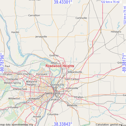
Rosewood Heights GPS coordinates[2]
38° 53' 16.188" North, 90° 5' 5.388" West
| Map corner | latitude | longitude |
|---|---|---|
| Upper-left | 39.43301°, | -90.78796° |
| Center: | 38.88783°, | -90.08483° |
| Lower-right: | 38.33843°, | -89.38171° |
| Map W x H: | 121.7×121.7 km | = 75.6×75.6mi |
| max Lat: | 71.29058° ⇑55.9% North |
| Rosewood Heights: | 38.88783° |
| min Lat: | ⇓44.1% South 19.06759° |
| min Long | Rosewood Height | max Long |
| -171.73463° | -90.08483° | -66.98998° |
| W 40.8%⇐ | ⇒59.2% E |
Elevation
Elevation of Rosewood Heights is 168 m = 551 ft, and this is 126.8 m = 416 ft below average elevation for this country.
| Max E: |
3189 m = 10463 ft | 57.5% |
| Avg. | 294.8 m = 967 ft | |
| Rosewood Heights | 168 m = 551 ft | |
Min E: |
-60 m = -197 ft | 42.5% |
See also: United States elevation on elevation.city.
Geographical zone
Rosewood Heights is located in North temperate zone (between Tropic of Cancer and the Arctic Circle). Distance of this Northern Tropic circle is 1718 km =1067.5 mi to South.| Distance of | km | miles | from Rosewood Heights |
|---|---|---|---|
| North Pole | 5683.1 | 3531.3 | to North |
| Arctic Circle | 3077.3 | 1912.1 | to North |
| Tropic Cancer | 1718 | 1067.5 | to South |
| Equator | 4323.9 | 2686.7 | to South |


Nearby cities:
15 places around Rosewood Heights: (largest is in red/bold)
• Alton
8.6 km =5.3 mi,  272°
272°
• Bethalto
4.5 km =2.8 mi,  58°
58°
• East Alton
2.4 km =1.5 mi,  249°
249°
• Edwardsville
14.2 km =8.8 mi,  126°
126°
• Godfrey
11.6 km =7.2 mi,  310°
310°
• Hartford
6.1 km =3.8 mi,  189°
189°
• Holiday Shores
13 km =8.1 mi,  73°
73°
• Mitchell
14 km =8.7 mi,  180°
180°
• Pontoon Beach
17.4 km =10.8 mi, 178°
• Roxana
4.4 km =2.7 mi,  170°
170°
• South Roxana
6.8 km =4.2 mi,  163°
163°
• Spanish Lake
15.9 km =9.9 mi,  225°
225°
• Upper Alton
6.3 km =3.9 mi,  294°
294°
• West Alton
12.2 km =7.6 mi,  258°
258°
• Wood River
3.2 km =2 mi,  200°
200°
Sources, notices
• [Note1] Compared only with cities in United States existing in our database
• [Src1] Map data: © OpenStreetMap contributors (CC-BY-SA)
• [Src2] Other city data from geonames.org with taken over terms of usage.
• [Src3] Geographical zone / Annual Mean Temperature by Robert A. Rohde @ Wikipedia
