Saint Elmo geodata
Saint Elmo (Illinois) is a populated place; located in United States in America/Chicago (GMT-5) time zone. With population of 1,426 people, there are 13985 cities with bigger population in this country. Compared to other cities in United States, 54.6% of cities are located further ↑North; 55.7% of cities are located further →East and 53.1% of cities have higher elevation than Saint Elmo. Note1


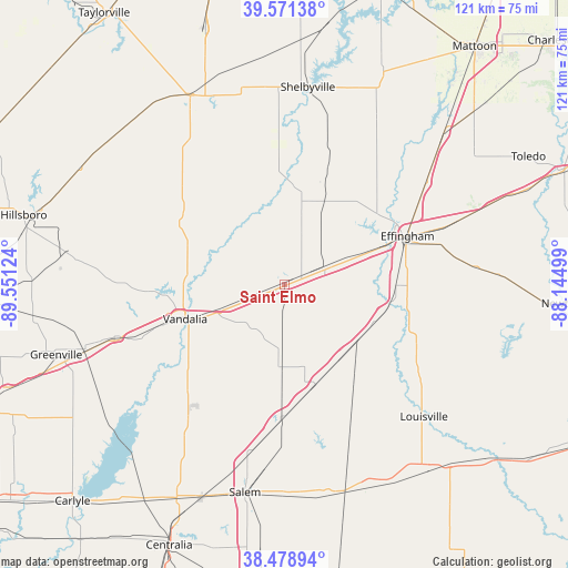
Saint Elmo GPS coordinates[2]
39° 1' 38.172" North, 88° 50' 53.196" West
| Map corner | latitude | longitude |
|---|---|---|
| Upper-left | 39.57138°, | -89.55124° |
| Center: | 39.02727°, | -88.84811° |
| Lower-right: | 38.47894°, | -88.14499° |
| Map W x H: | 121.5×121.5 km | = 75.5×75.5mi |
| max Lat: | 71.29058° ⇑54.6% North |
| Saint Elmo: | 39.02727° |
| min Lat: | ⇓45.4% South 19.06759° |
| min Long | Saint Elmo | max Long |
| -171.73463° | -88.84811° | -66.98998° |
| W 44.3%⇐ | ⇒55.7% E |
Elevation
Elevation of Saint Elmo is 187 m = 614 ft, and this is 107.8 m = 354 ft below average elevation for this country.
| Max E: |
3189 m = 10463 ft | 53.1% |
| Avg. | 294.8 m = 967 ft | |
| Saint Elmo | 187 m = 614 ft | |
Min E: |
-60 m = -197 ft | 46.9% |
See also: United States elevation on elevation.city.
Geographical zone
Saint Elmo is located in North temperate zone (between Tropic of Cancer and the Arctic Circle). Distance of this Northern Tropic circle is 1733.5 km =1077.1 mi to South.| Distance of | km | miles | from Saint Elmo |
|---|---|---|---|
| North Pole | 5667.6 | 3521.7 | to North |
| Arctic Circle | 3061.7 | 1902.5 | to North |
| Tropic Cancer | 1733.5 | 1077.1 | to South |
| Equator | 4339.4 | 2696.4 | to South |


Nearby cities:
15 places around Saint Elmo: (largest is in red/bold)
• Altamont
9.5 km =5.9 mi,  65°
65°
• Brownstown
9.7 km =6 mi,  248°
248°
• Cowden
24.6 km =15.3 mi,  357°
357°
• Dieterich
40.6 km =25.2 mi,  84°
84°
• Effingham
28.3 km =17.6 mi, 68°
• Farina
22.4 km =13.9 mi,  163°
163°
• Kinmundy
28.2 km =17.5 mi,  179°
179°
• Louisville
41.2 km =25.6 mi,  133°
133°
• Mulberry Grove
38.1 km =23.7 mi, 252°
• Patoka
37 km =23 mi,  215°
215°
• Ramsey
26 km =16.2 mi,  300°
300°
• Stewardson
32.3 km =20.1 mi,  35°
35°
• Teutopolis
34.5 km =21.4 mi, 70°
• Vandalia
22.5 km =14 mi, 250°
• Watson
24 km =14.9 mi,  90°
90°
Sources, notices
• [Note1] Compared only with cities in United States existing in our database
• [Src1] Map data: © OpenStreetMap contributors (CC-BY-SA)
• [Src2] Other city data from geonames.org with taken over terms of usage.
• [Src3] Geographical zone / Annual Mean Temperature by Robert A. Rohde @ Wikipedia
