Fountain City geodata
Fountain City (Indiana) is a populated place; located in United States in America/Indiana/Indianapolis (GMT-4) time zone. With population of 780 people, there are 17978 cities with bigger population in this country. Compared to other cities in United States, 53.1% of cities are located further ↓South; 56.1% of cities are located further ←West and 78% of cities have lower elevation than Fountain City. Note1


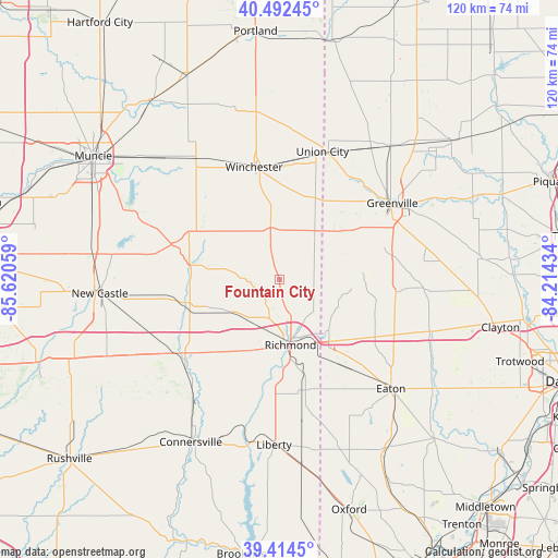
Fountain City GPS coordinates[2]
39° 57' 20.16" North, 84° 55' 2.856" West
| Map corner | latitude | longitude |
|---|---|---|
| Upper-left | 40.49245°, | -85.62059° |
| Center: | 39.9556°, | -84.91746° |
| Lower-right: | 39.4145°, | -84.21434° |
| Map W x H: | 119.9×119.9 km | = 74.5×74.5mi |
| max Lat: | 71.29058° ⇑46.9% North |
| Fountain City: | 39.9556° |
| min Lat: | ⇓53.1% South 19.06759° |
| min Long | Fountain City | max Long |
| -171.73463° | -84.91746° | -66.98998° |
| W 56.1%⇐ | ⇒43.9% E |
Elevation
Elevation of Fountain City is 336 m = 1102 ft, and this is 41.2 m = 135 ft above average elevation for this country.
| Max E: |
3189 m = 10463 ft | 22% |
| Fountain City | 336 m 1102 ft | |
| Avg. | 294.8 m = 967 ft | |
Min E: |
-60 m = -197 ft | 78% |
See also: United States elevation on elevation.city.
Geographical zone
Fountain City is located in North temperate zone (between Tropic of Cancer and the Arctic Circle). Distance of this Northern Tropic circle is 1836.7 km =1141.3 mi to South.| Distance of | km | miles | from Fountain City |
|---|---|---|---|
| North Pole | 5564.4 | 3457.6 | to North |
| Arctic Circle | 2958.5 | 1838.3 | to North |
| Tropic Cancer | 1836.7 | 1141.3 | to South |
| Equator | 4442.6 | 2760.5 | to South |


Nearby cities:
15 places around Fountain City: (largest is in red/bold)
• Arcanum
31.3 km =19.4 mi,  82°
82°
• Cambridge City
26.9 km =16.7 mi,  233°
233°
• Centerville
16.7 km =10.4 mi,  203°
203°
• Dublin
29.5 km =18.3 mi,  237°
237°
• Farmland
31.4 km =19.5 mi,  325°
325°
• Greenville
29.2 km =18.1 mi,  55°
55°
• Hagerstown
21.4 km =13.3 mi,  256°
256°
• Lynn
10.6 km =6.6 mi,  349°
349°
• New Madison
17.8 km =11.1 mi,  85°
85°
• New Paris
15.2 km =9.4 mi,  135°
135°
• Richmond
14.3 km =8.9 mi,  170°
170°
• Union City
28.8 km =17.9 mi,  19°
19°
• Union City
28.9 km =18 mi, 18°
• Wayne Lakes Park
23 km =14.3 mi,  70°
70°
• Winchester
24.7 km =15.3 mi, 347°
Sources, notices
• [Note1] Compared only with cities in United States existing in our database
• [Src1] Map data: © OpenStreetMap contributors (CC-BY-SA)
• [Src2] Other city data from geonames.org with taken over terms of usage.
• [Src3] Geographical zone / Annual Mean Temperature by Robert A. Rohde @ Wikipedia
