Burlington geodata
Burlington (Kentucky) is a seat of a second-order administrative division; located in United States in America/New_York (GMT-4) time zone. With population of 15,926 people, there are 3073 cities with bigger population in this country. Compared to other cities in United States, 54.6% of cities are located further ↑North; 56.6% of cities are located further ←West and 63.5% of cities have lower elevation than Burlington. Note1


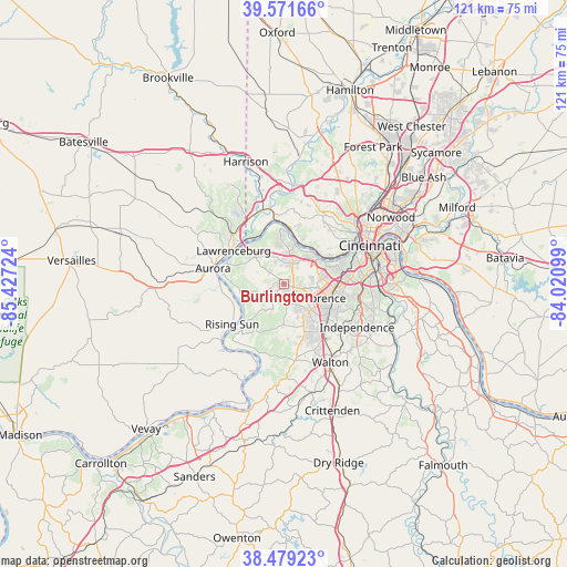
Burlington GPS coordinates[2]
39° 1' 39.216" North, 84° 43' 26.796" West
| Map corner | latitude | longitude |
|---|---|---|
| Upper-left | 39.57166°, | -85.42724° |
| Center: | 39.02756°, | -84.72411° |
| Lower-right: | 38.47923°, | -84.02099° |
| Map W x H: | 121.5×121.5 km | = 75.5×75.5mi |
| max Lat: | 71.29058° ⇑54.6% North |
| Burlington: | 39.02756° |
| min Lat: | ⇓45.4% South 19.06759° |
| min Long | Burlington | max Long |
| -171.73463° | -84.72411° | -66.98998° |
| W 56.6%⇐ | ⇒43.4% E |
Elevation
Elevation of Burlington is 255 m = 837 ft, and this is 39.8 m = 131 ft below average elevation for this country.
| Max E: |
3189 m = 10463 ft | 36.5% |
| Avg. | 294.8 m = 967 ft | |
| Burlington | 255 m = 837 ft | |
Min E: |
-60 m = -197 ft | 63.5% |
See also: United States elevation on elevation.city.
Geographical zone
Burlington is located in North temperate zone (between Tropic of Cancer and the Arctic Circle). Distance of this Northern Tropic circle is 1733.5 km =1077.1 mi to South.| Distance of | km | miles | from Burlington |
|---|---|---|---|
| North Pole | 5667.6 | 3521.7 | to North |
| Arctic Circle | 3061.7 | 1902.5 | to North |
| Tropic Cancer | 1733.5 | 1077.1 | to South |
| Equator | 4339.5 | 2696.4 | to South |


Nearby cities:
15 places around Burlington: (largest is in red/bold)
• Addyston
12.2 km =7.6 mi,  6°
6°
• Crescent Springs
12.6 km =7.8 mi,  77°
77°
• Crestview Hills
12 km =7.5 mi,  90°
90°
• Delhi Hills
12 km =7.5 mi,  52°
52°
• Edgewood
12.3 km =7.6 mi, 94°
• Elsmere
10.5 km =6.5 mi,  99°
99°
• Erlanger
10.7 km =6.6 mi, 96°
• Florence
9 km =5.6 mi,  110°
110°
• Francisville
8.6 km =5.3 mi,  359°
359°
• Hebron
4.7 km =2.9 mi,  25°
25°
• Lawrenceburg
12.9 km =8 mi,  302°
302°
• Oakbrook
4.6 km =2.9 mi,  132°
132°
• Petersburg
13.3 km =8.3 mi,  290°
290°
• Union
9.8 km =6.1 mi,  157°
157°
• Villa Hills
12 km =7.5 mi,  70°
70°
Sources, notices
• [Note1] Compared only with cities in United States existing in our database
• [Src1] Map data: © OpenStreetMap contributors (CC-BY-SA)
• [Src2] Other city data from geonames.org with taken over terms of usage.
• [Src3] Geographical zone / Annual Mean Temperature by Robert A. Rohde @ Wikipedia
