Independence geodata
Independence (Kentucky) is a populated place; located in United States in America/New_York (GMT-4) time zone. With population of 26,819 people, there are 1871 cities with bigger population in this country. Compared to other cities in United States, 55.5% of cities are located further ↑North; 57.3% of cities are located further ←West and 67.6% of cities have lower elevation than Independence. Note1


Independence GPS coordinates[2]
38° 56' 35.232" North, 84° 32' 38.796" West
| Map corner | latitude | longitude |
|---|---|---|
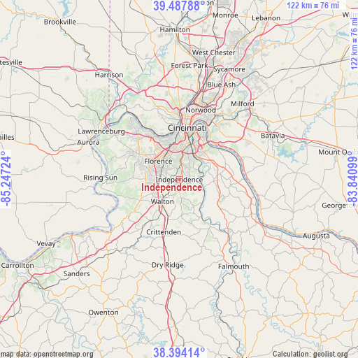
| Upper-left | 39.48788°, | -85.24724° |
| Center: | 38.94312°, | -84.54411° |
| Lower-right: | 38.39414°, | -83.84099° |
| Map W x H: | 121.6×121.6 km | = 75.6×75.6mi |
| max Lat: | 71.29058° ⇑55.5% North |
| Independence: | 38.94312° |
| min Lat: | ⇓44.5% South 19.06759° |
| min Long | Independence | max Long |
| -171.73463° | -84.54411° | -66.98998° |
| W 57.3%⇐ | ⇒42.7% E |
Elevation
Elevation of Independence is 274 m = 899 ft, and this is 20.8 m = 68 ft below average elevation for this country.
| Max E: |
3189 m = 10463 ft | 32.4% |
| Avg. | 294.8 m = 967 ft | |
| Independence | 274 m = 899 ft | |
Min E: |
-60 m = -197 ft | 67.6% |
See also: United States elevation on elevation.city.
Geographical zone
Independence is located in North temperate zone (between Tropic of Cancer and the Arctic Circle). Distance of this Northern Tropic circle is 1724.2 km =1071.4 mi to South.| Distance of | km | miles | from Independence |
|---|---|---|---|
| North Pole | 5677 | 3527.5 | to North |
| Arctic Circle | 3071.1 | 1908.3 | to North |
| Tropic Cancer | 1724.2 | 1071.4 | to South |
| Equator | 4330.1 | 2690.6 | to South |


Nearby cities:
15 places around Independence: (largest is in red/bold)
• Cold Spring
12.5 km =7.8 mi,  45°
45°
• Crescent Springs
12.5 km =7.8 mi,  344°
344°
• Crestview Hills
10 km =6.2 mi, 339°
• Edgewood
9 km =5.6 mi, 338°
• Elsmere
9.3 km =5.8 mi,  325°
325°
• Erlanger
9.5 km =5.9 mi, 329°
• Florence
9.5 km =5.9 mi,  311°
311°
• Fort Mitchell
12.9 km =8 mi,  358°
358°
• Fort Wright
12.1 km =7.5 mi,  4°
4°
• Highland Heights
12.8 km =8 mi,  38°
38°
• Lakeside Park
10.5 km =6.5 mi,  348°
348°
• Ryland Heights
7.2 km =4.5 mi,  77°
77°
• Taylor Mill
7.3 km =4.5 mi,  34°
34°
• Union
11.8 km =7.3 mi,  271°
271°
• Walton
9.4 km =5.8 mi,  217°
217°
Sources, notices
• [Note1] Compared only with cities in United States existing in our database
• [Src1] Map data: © OpenStreetMap contributors (CC-BY-SA)
• [Src2] Other city data from geonames.org with taken over terms of usage.
• [Src3] Geographical zone / Annual Mean Temperature by Robert A. Rohde @ Wikipedia
