Silver Grove geodata
Silver Grove (Kentucky) is a populated place; located in United States in America/New_York (GMT-4) time zone. With population of 1,120 people, there are 15564 cities with bigger population in this country. Compared to other cities in United States, 54.5% of cities are located further ↑North; 57.8% of cities are located further ←West and 60.1% of cities have higher elevation than Silver Grove. Note1


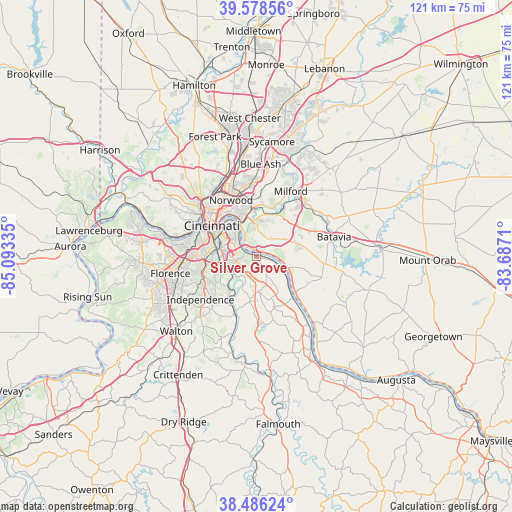
Silver Grove GPS coordinates[2]
39° 2' 4.236" North, 84° 23' 24.792" West
| Map corner | latitude | longitude |
|---|---|---|
| Upper-left | 39.57856°, | -85.09335° |
| Center: | 39.03451°, | -84.39022° |
| Lower-right: | 38.48624°, | -83.6871° |
| Map W x H: | 121.5×121.5 km | = 75.5×75.5mi |
| max Lat: | 71.29058° ⇑54.5% North |
| Silver Grove: | 39.03451° |
| min Lat: | ⇓45.5% South 19.06759° |
| min Long | Silver Grove | max Long |
| -171.73463° | -84.39022° | -66.98998° |
| W 57.8%⇐ | ⇒42.2% E |
Elevation
Elevation of Silver Grove is 154 m = 505 ft, and this is 140.8 m = 462 ft below average elevation for this country.
| Max E: |
3189 m = 10463 ft | 60.1% |
| Avg. | 294.8 m = 967 ft | |
| Silver Grove | 154 m = 505 ft | |
Min E: |
-60 m = -197 ft | 39.9% |
See also: United States elevation on elevation.city.
Geographical zone
Silver Grove is located in North temperate zone (between Tropic of Cancer and the Arctic Circle). Distance of this Northern Tropic circle is 1734.3 km =1077.6 mi to South.| Distance of | km | miles | from Silver Grove |
|---|---|---|---|
| North Pole | 5666.8 | 3521.2 | to North |
| Arctic Circle | 3060.9 | 1902 | to North |
| Tropic Cancer | 1734.3 | 1077.6 | to South |
| Equator | 4340.2 | 2696.9 | to South |


Nearby cities:
15 places around Silver Grove: (largest is in red/bold)
• Alexandria
8.3 km =5.2 mi,  178°
178°
• Cherry Grove
7.3 km =4.5 mi,  54°
54°
• Cold Spring
4.5 km =2.8 mi,  251°
251°
• Dry Run
9.3 km =5.8 mi,  33°
33°
• Forestville
6 km =3.7 mi,  40°
40°
• Fort Thomas
6.7 km =4.2 mi,  312°
312°
• Fruit Hill
5.1 km =3.2 mi, 26°
• Highland Heights
5.3 km =3.3 mi,  268°
268°
• Salem Heights
4.3 km =2.7 mi,  13°
13°
• Sherwood
6.1 km =3.8 mi,  24°
24°
• Southgate
8.3 km =5.2 mi,  300°
300°
• Taylor Mill
10 km =6.2 mi, 245°
• Turpin Hills
8.4 km =5.2 mi, 6°
• Wilder
8.7 km =5.4 mi,  286°
286°
• Withamsville
9.3 km =5.8 mi,  70°
70°
Sources, notices
• [Note1] Compared only with cities in United States existing in our database
• [Src1] Map data: © OpenStreetMap contributors (CC-BY-SA)
• [Src2] Other city data from geonames.org with taken over terms of usage.
• [Src3] Geographical zone / Annual Mean Temperature by Robert A. Rohde @ Wikipedia
