Worthington geodata
Worthington (Kentucky) is a populated place; located in United States in America/Kentucky/Louisville (GMT-4) time zone. With population of 1,643 people, there are 13113 cities with bigger population in this country. Compared to other cities in United States, 59.9% of cities are located further ↑North; 54.4% of cities are located further ←West and 53.7% of cities have lower elevation than Worthington. Note1


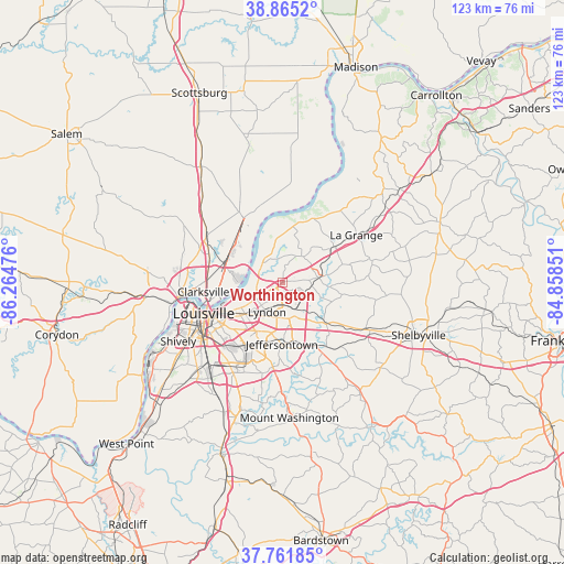
Worthington GPS coordinates[2]
38° 18' 56.232" North, 85° 33' 41.868" West
| Map corner | latitude | longitude |
|---|---|---|
| Upper-left | 38.8652°, | -86.26476° |
| Center: | 38.31562°, | -85.56163° |
| Lower-right: | 37.76185°, | -84.85851° |
| Map W x H: | 122.7×122.7 km | = 76.2×76.2mi |
| max Lat: | 71.29058° ⇑59.9% North |
| Worthington: | 38.31562° |
| min Lat: | ⇓40.1% South 19.06759° |
| min Long | Worthington | max Long |
| -171.73463° | -85.56163° | -66.98998° |
| W 54.4%⇐ | ⇒45.6% E |
Elevation
Elevation of Worthington is 213 m = 699 ft, and this is 81.8 m = 268 ft below average elevation for this country.
| Max E: |
3189 m = 10463 ft | 46.3% |
| Avg. | 294.8 m = 967 ft | |
| Worthington | 213 m = 699 ft | |
Min E: |
-60 m = -197 ft | 53.7% |
See also: United States elevation on elevation.city.
Geographical zone
Worthington is located in North temperate zone (between Tropic of Cancer and the Arctic Circle). Distance of this Northern Tropic circle is 1654.4 km =1028 mi to South.| Distance of | km | miles | from Worthington |
|---|---|---|---|
| North Pole | 5746.8 | 3570.9 | to North |
| Arctic Circle | 3140.9 | 1951.7 | to North |
| Tropic Cancer | 1654.4 | 1028 | to South |
| Equator | 4260.3 | 2647.2 | to South |


Nearby cities:
15 places around Worthington: (largest is in red/bold)
• Bancroft
5.7 km =3.5 mi,  230°
230°
• Barbourmeade
4.2 km =2.6 mi,  240°
240°
• Brownsboro Farm
3.3 km =2.1 mi, 244°
• Coldstream
3.3 km =2.1 mi,  91°
91°
• Fincastle
1.9 km =1.2 mi,  116°
116°
• Green Spring
4.6 km =2.9 mi,  270°
270°
• Langdon Place
3.6 km =2.2 mi,  211°
211°
• Meadow Vale
3.7 km =2.3 mi,  193°
193°
• Murray Hill
3.6 km =2.2 mi,  219°
219°
• Orchard Grass Hills
3.6 km =2.2 mi,  75°
75°
• Plantation
4.4 km =2.7 mi, 215°
• Rolling Hills
3.8 km =2.4 mi,  196°
196°
• Spring Valley
4.8 km =3 mi, 244°
• Westwood
4.4 km =2.7 mi, 204°
• Worthington Hills
3.1 km =1.9 mi,  103°
103°
Sources, notices
• [Note1] Compared only with cities in United States existing in our database
• [Src1] Map data: © OpenStreetMap contributors (CC-BY-SA)
• [Src2] Other city data from geonames.org with taken over terms of usage.
• [Src3] Geographical zone / Annual Mean Temperature by Robert A. Rohde @ Wikipedia
