Iota geodata
Iota (Louisiana) is a populated place; located in United States in America/Chicago (GMT-5) time zone. With population of 1,480 people, there are 13750 cities with bigger population in this country. Compared to other cities in United States, 92.4% of cities are located further ↑North; 65.2% of cities are located further →East and 92.1% of cities have higher elevation than Iota. Note1


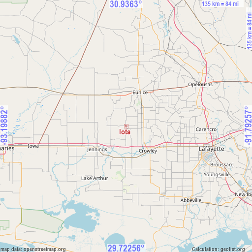
Iota GPS coordinates[2]
30° 19' 52.716" North, 92° 29' 44.484" West
| Map corner | latitude | longitude |
|---|---|---|
| Upper-left | 30.9363°, | -93.19882° |
| Center: | 30.33131°, | -92.49569° |
| Lower-right: | 29.72256°, | -91.79257° |
| Map W x H: | 135×135 km | = 83.9×83.9mi |
| max Lat: | 71.29058° ⇑92.4% North |
| Iota: | 30.33131° |
| min Lat: | ⇓7.6% South 19.06759° |
| min Long | Iota | max Long |
| -171.73463° | -92.49569° | -66.98998° |
| W 34.8%⇐ | ⇒65.2% E |
Elevation
Elevation of Iota is 12 m = 39 ft, and this is 282.8 m = 928 ft below average elevation for this country.
| Max E: |
3189 m = 10463 ft | 92.1% |
| Avg. | 294.8 m = 967 ft | |
| Iota | 12 m = 39 ft | |
Min E: |
-60 m = -197 ft | 7.9% |
See also: United States elevation on elevation.city.
Geographical zone
Iota is located in North temperate zone (between Tropic of Cancer and the Arctic Circle). Distance of this Northern Tropic circle is 766.6 km =476.3 mi to South.| Distance of | km | miles | from Iota |
|---|---|---|---|
| North Pole | 6634.5 | 4122.5 | to North |
| Arctic Circle | 4028.6 | 2503.3 | to North |
| Tropic Cancer | 766.6 | 476.3 | to South |
| Equator | 3372.5 | 2095.6 | to South |


Nearby cities:
15 places around Iota: (largest is in red/bold)
• Basile
19.6 km =12.2 mi,  330°
330°
• Church Point
28.1 km =17.5 mi,  73°
73°
• Crowley
17.5 km =10.9 mi,  138°
138°
• Duson
31.6 km =19.6 mi,  109°
109°
• Egan
10.5 km =6.5 mi,  185°
185°
• Elton
25.4 km =15.8 mi,  311°
311°
• Estherwood
17 km =10.6 mi,  169°
169°
• Eunice
19.6 km =12.2 mi,  22°
22°
• Jennings
19.7 km =12.2 mi,  232°
232°
• Lake Arthur
32.6 km =20.3 mi,  211°
211°
• Mermentau
17.8 km =11.1 mi, 207°
• Morse
23.3 km =14.5 mi,  180°
180°
• Rayne
24.3 km =15.1 mi,  116°
116°
• Roanoke
26.3 km =16.3 mi,  246°
246°
• Welsh
33.1 km =20.6 mi, 251°
Sources, notices
• [Note1] Compared only with cities in United States existing in our database
• [Src1] Map data: © OpenStreetMap contributors (CC-BY-SA)
• [Src2] Other city data from geonames.org with taken over terms of usage.
• [Src3] Geographical zone / Annual Mean Temperature by Robert A. Rohde @ Wikipedia
