Bethesda geodata
Bethesda (Maryland) is a populated place; located in United States in America/New_York (GMT-4) time zone. With population of 60,858 people, there are 723 cities with bigger population in this country. Compared to other cities in United States, 55.1% of cities are located further ↑North; 80.1% of cities are located further ←West and 70.6% of cities have higher elevation than Bethesda. Note1


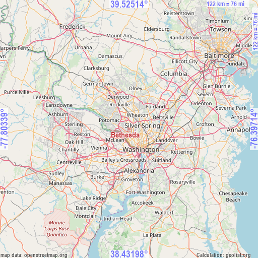
Bethesda GPS coordinates[2]
38° 58' 50.412" North, 77° 6' 0.936" West
| Map corner | latitude | longitude |
|---|---|---|
| Upper-left | 39.52514°, | -77.80339° |
| Center: | 38.98067°, | -77.10026° |
| Lower-right: | 38.43198°, | -76.39714° |
| Map W x H: | 121.5×121.5 km | = 75.5×75.5mi |
| max Lat: | 71.29058° ⇑55.1% North |
| Bethesda: | 38.98067° |
| min Lat: | ⇓44.9% South 19.06759° |
| min Long | Bethesda | max Long |
| -171.73463° | -77.10026° | -66.98998° |
| W 80.1%⇐ | ⇒19.9% E |
Elevation
Elevation of Bethesda is 97 m = 318 ft, and this is 197.8 m = 649 ft below average elevation for this country.
| Max E: |
3189 m = 10463 ft | 70.6% |
| Avg. | 294.8 m = 967 ft | |
| Bethesda | 97 m = 318 ft | |
Min E: |
-60 m = -197 ft | 29.4% |
See also: Bethesda elevation on elevation.city.
Geographical zone
Bethesda is located in North temperate zone (between Tropic of Cancer and the Arctic Circle). Distance of this Northern Tropic circle is 1728.3 km =1073.9 mi to South.| Distance of | km | miles | from Bethesda |
|---|---|---|---|
| North Pole | 5672.8 | 3524.9 | to North |
| Arctic Circle | 3066.9 | 1905.7 | to North |
| Tropic Cancer | 1728.3 | 1073.9 | to South |
| Equator | 4334.2 | 2693.1 | to South |


Nearby cities:
15 places around Bethesda: (largest is in red/bold)
• Brookmont
4.6 km =2.9 mi,  201°
201°
• Cabin John
5 km =3.1 mi,  263°
263°
• Chevy Chase
3.4 km =2.1 mi,  123°
123°
• Chevy Chase
3.5 km =2.2 mi,  45°
45°
• Chevy Chase Section Five
2.3 km =1.4 mi,  81°
81°
• Chevy Chase Section Three
2.3 km =1.4 mi,  94°
94°
• Chevy Chase View
4.6 km =2.9 mi,  19°
19°
• Chevy Chase Village
2.2 km =1.4 mi, 124°
• Forest Glen
5.4 km =3.4 mi, 46°
• Friendship Village
2.2 km =1.4 mi,  153°
153°
• Kensington
5.4 km =3.4 mi, 22°
• Martins Additions
2.7 km =1.7 mi, 93°
• North Chevy Chase
3.3 km =2.1 mi, 46°
• Somerset
1.7 km =1.1 mi,  167°
167°
• South Kensington
4.6 km =2.9 mi, 22°
Sources, notices
• [Note1] Compared only with cities in United States existing in our database
• [Src1] Map data: © OpenStreetMap contributors (CC-BY-SA)
• [Src2] Other city data from geonames.org with taken over terms of usage.
• [Src3] Geographical zone / Annual Mean Temperature by Robert A. Rohde @ Wikipedia
