Fruitland geodata
Fruitland (Maryland) is a populated place; located in United States in America/New_York (GMT-4) time zone. With population of 5,215 people, there are 6982 cities with bigger population in this country. Compared to other cities in United States, 59.8% of cities are located further ↑North; 85.2% of cities are located further ←West and 92.1% of cities have higher elevation than Fruitland. Note1


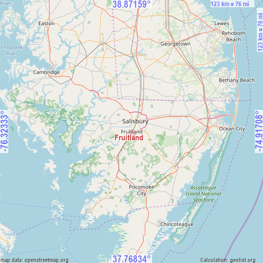
Fruitland GPS coordinates[2]
38° 19' 19.416" North, 75° 37' 12.72" West
| Map corner | latitude | longitude |
|---|---|---|
| Upper-left | 38.87159°, | -76.32333° |
| Center: | 38.32206°, | -75.6202° |
| Lower-right: | 37.76834°, | -74.91708° |
| Map W x H: | 122.7×122.7 km | = 76.2×76.2mi |
| max Lat: | 71.29058° ⇑59.8% North |
| Fruitland: | 38.32206° |
| min Lat: | ⇓40.2% South 19.06759° |
| min Long | Fruitland | max Long |
| -171.73463° | -75.6202° | -66.98998° |
| W 85.2%⇐ | ⇒14.8% E |
Elevation
Elevation of Fruitland is 12 m = 39 ft, and this is 282.8 m = 928 ft below average elevation for this country.
| Max E: |
3189 m = 10463 ft | 92.1% |
| Avg. | 294.8 m = 967 ft | |
| Fruitland | 12 m = 39 ft | |
Min E: |
-60 m = -197 ft | 7.9% |
See also: United States elevation on elevation.city.
Geographical zone
Fruitland is located in North temperate zone (between Tropic of Cancer and the Arctic Circle). Distance of this Northern Tropic circle is 1655.1 km =1028.4 mi to South.| Distance of | km | miles | from Fruitland |
|---|---|---|---|
| North Pole | 5746 | 3570.4 | to North |
| Arctic Circle | 3140.2 | 1951.2 | to North |
| Tropic Cancer | 1655.1 | 1028.4 | to South |
| Equator | 4261 | 2647.7 | to South |


Nearby cities:
15 places around Fruitland: (largest is in red/bold)
• Berlin
35.1 km =21.8 mi,  89°
89°
• Blades
34.9 km =21.7 mi,  1°
1°
• Delmar
15.4 km =9.6 mi,  14°
14°
• Eden
5.3 km =3.3 mi,  210°
210°
• Hebron
12.4 km =7.7 mi,  331°
331°
• Laurel
26.4 km =16.4 mi, 9°
• Mount Vernon
19.5 km =12.1 mi,  244°
244°
• Pittsville
19.8 km =12.3 mi,  65°
65°
• Pocomoke City
27.8 km =17.3 mi,  170°
170°
• Princess Anne
14.7 km =9.1 mi, 205°
• Salisbury
4.7 km =2.9 mi,  22°
22°
• Seaford
35.5 km =22.1 mi, 1°
• Sharptown
26 km =16.2 mi,  340°
340°
• Snow Hill
25.6 km =15.9 mi,  129°
129°
• Willards
24.9 km =15.5 mi, 72°
Sources, notices
• [Note1] Compared only with cities in United States existing in our database
• [Src1] Map data: © OpenStreetMap contributors (CC-BY-SA)
• [Src2] Other city data from geonames.org with taken over terms of usage.
• [Src3] Geographical zone / Annual Mean Temperature by Robert A. Rohde @ Wikipedia
