Hurlock geodata
Hurlock (Maryland) is a populated place; located in United States in America/New_York (GMT-4) time zone. With population of 2,092 people, there are 11650 cities with bigger population in this country. Compared to other cities in United States, 57.9% of cities are located further ↑North; 84.5% of cities are located further ←West and 90.5% of cities have higher elevation than Hurlock. Note1


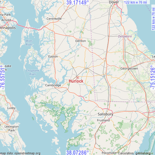
Hurlock GPS coordinates[2]
38° 37' 27.408" North, 75° 51' 15.768" West
| Map corner | latitude | longitude |
|---|---|---|
| Upper-left | 39.17149°, | -76.55751° |
| Center: | 38.62428°, | -75.85438° |
| Lower-right: | 38.07286°, | -75.15126° |
| Map W x H: | 122.2×122.2 km | = 75.9×75.9mi |
| max Lat: | 71.29058° ⇑57.9% North |
| Hurlock: | 38.62428° |
| min Lat: | ⇓42.1% South 19.06759° |
| min Long | Hurlock | max Long |
| -171.73463° | -75.85438° | -66.98998° |
| W 84.5%⇐ | ⇒15.5% E |
Elevation
Elevation of Hurlock is 15 m = 49 ft, and this is 279.8 m = 918 ft below average elevation for this country.
| Max E: |
3189 m = 10463 ft | 90.5% |
| Avg. | 294.8 m = 967 ft | |
| Hurlock | 15 m = 49 ft | |
Min E: |
-60 m = -197 ft | 9.5% |
See also: United States elevation on elevation.city.
Geographical zone
Hurlock is located in North temperate zone (between Tropic of Cancer and the Arctic Circle). Distance of this Northern Tropic circle is 1688.7 km =1049.3 mi to South.| Distance of | km | miles | from Hurlock |
|---|---|---|---|
| North Pole | 5712.4 | 3549.5 | to North |
| Arctic Circle | 3106.6 | 1930.4 | to North |
| Tropic Cancer | 1688.7 | 1049.3 | to South |
| Equator | 4294.6 | 2668.5 | to South |


Nearby cities:
15 places around Hurlock: (largest is in red/bold)
• Algonquin
22.3 km =13.9 mi,  258°
258°
• Blades
21.3 km =13.2 mi,  86°
86°
• Bridgeville
25.4 km =15.8 mi,  58°
58°
• Cambridge
20.7 km =12.9 mi,  250°
250°
• Denton
29 km =18 mi,  4°
4°
• Easton
25.5 km =15.8 mi,  310°
310°
• Federalsburg
10.6 km =6.6 mi,  42°
42°
• Hebron
26.9 km =16.7 mi,  147°
147°
• Laurel
25.7 km =16 mi,  107°
107°
• Oxford
28.4 km =17.6 mi,  284°
284°
• Preston
10.9 km =6.8 mi,  333°
333°
• Seaford
21.2 km =13.2 mi,  84°
84°
• Secretary
8.3 km =5.2 mi, 258°
• Sharptown
14.8 km =9.2 mi,  127°
127°
• Trappe
18.1 km =11.2 mi, 282°
Sources, notices
• [Note1] Compared only with cities in United States existing in our database
• [Src1] Map data: © OpenStreetMap contributors (CC-BY-SA)
• [Src2] Other city data from geonames.org with taken over terms of usage.
• [Src3] Geographical zone / Annual Mean Temperature by Robert A. Rohde @ Wikipedia
