Mount Airy geodata
Mount Airy (Maryland) is a populated place; located in United States in America/New_York (GMT-4) time zone. With population of 9,380 people, there are 4657 cities with bigger population in this country. Compared to other cities in United States, 51.7% of cities are located further ↑North; 80% of cities are located further ←West and 59% of cities have lower elevation than Mount Airy. Note1


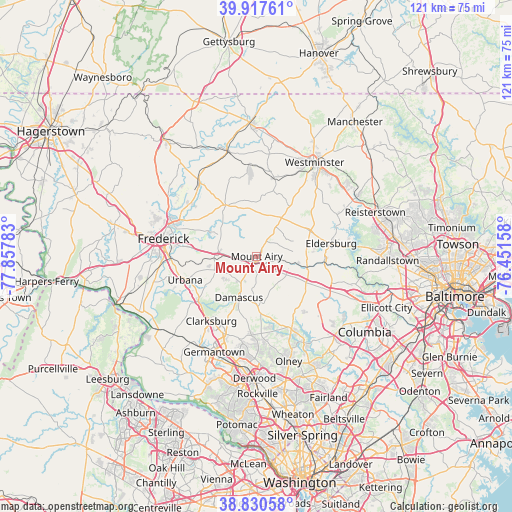
Mount Airy GPS coordinates[2]
39° 22' 34.356" North, 77° 9' 16.92" West
| Map corner | latitude | longitude |
|---|---|---|
| Upper-left | 39.91761°, | -77.85783° |
| Center: | 39.37621°, | -77.1547° |
| Lower-right: | 38.83058°, | -76.45158° |
| Map W x H: | 120.9×120.9 km | = 75.1×75.1mi |
| max Lat: | 71.29058° ⇑51.7% North |
| Mount Airy: | 39.37621° |
| min Lat: | ⇓48.3% South 19.06759° |
| min Long | Mount Airy | max Long |
| -171.73463° | -77.1547° | -66.98998° |
| W 80%⇐ | ⇒20% E |
Elevation
Elevation of Mount Airy is 235 m = 771 ft, and this is 59.8 m = 196 ft below average elevation for this country.
| Max E: |
3189 m = 10463 ft | 41% |
| Avg. | 294.8 m = 967 ft | |
| Mount Airy | 235 m = 771 ft | |
Min E: |
-60 m = -197 ft | 59% |
See also: United States elevation on elevation.city.
Geographical zone
Mount Airy is located in North temperate zone (between Tropic of Cancer and the Arctic Circle). Distance of this Northern Tropic circle is 1772.3 km =1101.3 mi to South.| Distance of | km | miles | from Mount Airy |
|---|---|---|---|
| North Pole | 5628.8 | 3497.6 | to North |
| Arctic Circle | 3022.9 | 1878.3 | to North |
| Tropic Cancer | 1772.3 | 1101.3 | to South |
| Equator | 4378.2 | 2720.5 | to South |


Nearby cities:
15 places around Mount Airy: (largest is in red/bold)
• Bartonsville
17.6 km =10.9 mi,  275°
275°
• Clarksburg
18.7 km =11.6 mi,  215°
215°
• Damascus
10.6 km =6.6 mi,  203°
203°
• Eldersburg
17.8 km =11.1 mi,  80°
80°
• Green Valley
14.3 km =8.9 mi,  238°
238°
• Libertytown
14.2 km =8.8 mi,  328°
328°
• Linganore
8.5 km =5.3 mi, 327°
• New Market
9.9 km =6.2 mi,  274°
274°
• New Windsor
18.9 km =11.7 mi,  12°
12°
• Spring Ridge
17.2 km =10.7 mi, 279°
• Sykesville
16.1 km =10 mi,  90°
90°
• Union Bridge
21.5 km =13.4 mi,  354°
354°
• Urbana
17.8 km =11.1 mi,  251°
251°
• Walkersville
20.9 km =13 mi,  305°
305°
• Woodsboro
22.2 km =13.8 mi,  321°
321°
Sources, notices
• [Note1] Compared only with cities in United States existing in our database
• [Src1] Map data: © OpenStreetMap contributors (CC-BY-SA)
• [Src2] Other city data from geonames.org with taken over terms of usage.
• [Src3] Geographical zone / Annual Mean Temperature by Robert A. Rohde @ Wikipedia
