Bel-Nor geodata
Bel-Nor (Missouri) is a populated place; located in United States in America/Chicago (GMT-5) time zone. With population of 1,482 people, there are 13740 cities with bigger population in this country. Compared to other cities in United States, 57.4% of cities are located further ↑North; 60.1% of cities are located further →East and 50.5% of cities have higher elevation than Bel-Nor. Note1
Administrative division(s):
- Level 1: Missouri
- Level 2: Saint Louis County
- Level 3: Township of Normandy


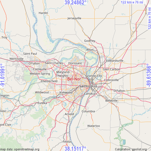
Bel-Nor GPS coordinates[2]
38° 42' 7.2" North, 90° 19' 0.408" West
| Map corner | latitude | longitude |
|---|---|---|
| Upper-left | 39.24862°, | -91.01991° |
| Center: | 38.702°, | -90.31678° |
| Lower-right: | 38.15117°, | -89.61366° |
| Map W x H: | 122×122 km | = 75.8×75.8mi |
| max Lat: | 71.29058° ⇑57.4% North |
| Bel-Nor: | 38.702° |
| min Lat: | ⇓42.6% South 19.06759° |
| min Long | Bel-Nor | max Long |
| -171.73463° | -90.31678° | -66.98998° |
| W 39.9%⇐ | ⇒60.1% E |
Elevation
Elevation of Bel-Nor is 196 m = 643 ft, and this is 98.8 m = 324 ft below average elevation for this country.
| Max E: |
3189 m = 10463 ft | 50.5% |
| Avg. | 294.8 m = 967 ft | |
| Bel-Nor | 196 m = 643 ft | |
Min E: |
-60 m = -197 ft | 49.5% |
See also: United States elevation on elevation.city.
Geographical zone
Bel-Nor is located in North temperate zone (between Tropic of Cancer and the Arctic Circle). Distance of this Northern Tropic circle is 1697.3 km =1054.7 mi to South.| Distance of | km | miles | from Bel-Nor |
|---|---|---|---|
| North Pole | 5703.8 | 3544.2 | to North |
| Arctic Circle | 3097.9 | 1924.9 | to North |
| Tropic Cancer | 1697.3 | 1054.7 | to South |
| Equator | 4303.3 | 2673.9 | to South |


Nearby cities:
15 places around Bel-Nor: (largest is in red/bold)
• Bel-Ridge
1.1 km =0.7 mi,  318°
318°
• Beverly Hills
2.1 km =1.3 mi,  95°
95°
• Charlack
2.3 km =1.4 mi,  271°
271°
• Cool Valley
2.9 km =1.8 mi,  11°
11°
• Greendale
0.8 km =0.5 mi,  157°
157°
• Hanley Hills
1.9 km =1.2 mi,  198°
198°
• Normandy
2.7 km =1.7 mi,  38°
38°
• Northwoods
2.9 km =1.8 mi,  85°
85°
• Norwood Court
2.8 km =1.7 mi,  49°
49°
• Pagedale
2.2 km =1.4 mi, 158°
• Pasadena Hills
2.2 km =1.4 mi,  71°
71°
• Saint Johns
2.6 km =1.6 mi,  298°
298°
• Velda Village
2.4 km =1.5 mi,  124°
124°
• Velda Village Hills
2.9 km =1.8 mi, 116°
• Vinita Park
2.6 km =1.6 mi,  239°
239°
Sources, notices
• [Note1] Compared only with cities in United States existing in our database
• [Src1] Map data: © OpenStreetMap contributors (CC-BY-SA)
• [Src2] Other city data from geonames.org with taken over terms of usage.
• [Src3] Geographical zone / Annual Mean Temperature by Robert A. Rohde @ Wikipedia
