Richmond Heights geodata
Richmond Heights (Missouri) is a populated place; located in United States in America/Chicago (GMT-5) time zone. With population of 8,481 people, there are 5026 cities with bigger population in this country. Compared to other cities in United States, 57.9% of cities are located further ↑North; 60.1% of cities are located further →East and 58.4% of cities have higher elevation than Richmond Heights. Note1
Administrative division(s):
- Level 1: Missouri
- Level 2: Saint Louis County
- Level 3: Township of Hadley


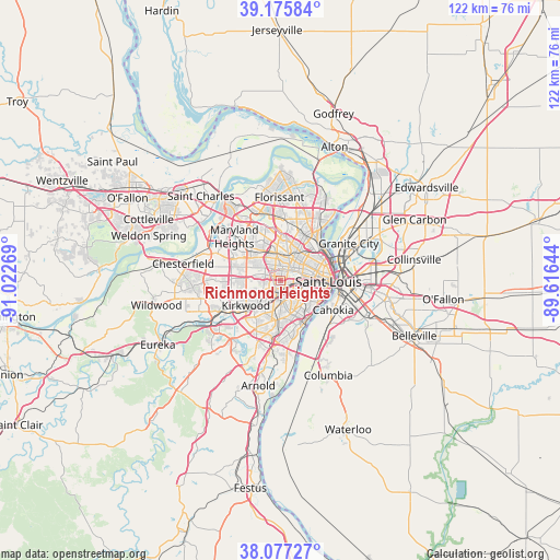
Richmond Heights GPS coordinates[2]
38° 37' 43.176" North, 90° 19' 10.416" West
| Map corner | latitude | longitude |
|---|---|---|
| Upper-left | 39.17584°, | -91.02269° |
| Center: | 38.62866°, | -90.31956° |
| Lower-right: | 38.07727°, | -89.61644° |
| Map W x H: | 122.1×122.1 km | = 75.9×75.9mi |
| max Lat: | 71.29058° ⇑57.9% North |
| Richmond Heights: | 38.62866° |
| min Lat: | ⇓42.1% South 19.06759° |
| min Long | Richmond Height | max Long |
| -171.73463° | -90.31956° | -66.98998° |
| W 39.9%⇐ | ⇒60.1% E |
Elevation
Elevation of Richmond Heights is 163 m = 535 ft, and this is 131.8 m = 432 ft below average elevation for this country.
| Max E: |
3189 m = 10463 ft | 58.4% |
| Avg. | 294.8 m = 967 ft | |
| Richmond Heights | 163 m = 535 ft | |
Min E: |
-60 m = -197 ft | 41.6% |
See also: United States elevation on elevation.city.
Geographical zone
Richmond Heights is located in North temperate zone (between Tropic of Cancer and the Arctic Circle). Distance of this Northern Tropic circle is 1689.2 km =1049.6 mi to South.| Distance of | km | miles | from Richmond Heights |
|---|---|---|---|
| North Pole | 5712 | 3549.3 | to North |
| Arctic Circle | 3106.1 | 1930 | to North |
| Tropic Cancer | 1689.2 | 1049.6 | to South |
| Equator | 4295.1 | 2668.9 | to South |


Nearby cities:
15 places around Richmond Heights: (largest is in red/bold)
• Benton
1.8 km =1.1 mi,  128°
128°
• Brentwood
2.9 km =1.8 mi,  244°
244°
• Clayton
1.6 km =1 mi,  346°
346°
• Glendale
6.2 km =3.9 mi,  233°
233°
• Hanley Hills
6.4 km =4 mi,  356°
356°
• Ladue
5.8 km =3.6 mi,  293°
293°
• Maplewood
1.8 km =1.1 mi,  193°
193°
• Olivette
6.4 km =4 mi,  309°
309°
• Pagedale
6.2 km =3.9 mi,  9°
9°
• Rock Hill
5.6 km =3.5 mi,  245°
245°
• Shrewsbury
4.5 km =2.8 mi,  199°
199°
• University City
3.2 km =2 mi,  16°
16°
• Warson Woods
6 km =3.7 mi, 246°
• Webster Groves
5.2 km =3.2 mi,  219°
219°
• Wellston
5.2 km =3.2 mi, 19°
Sources, notices
• [Note1] Compared only with cities in United States existing in our database
• [Src1] Map data: © OpenStreetMap contributors (CC-BY-SA)
• [Src2] Other city data from geonames.org with taken over terms of usage.
• [Src3] Geographical zone / Annual Mean Temperature by Robert A. Rohde @ Wikipedia
