Aberdeen geodata
Aberdeen (Mississippi) is a seat of a second-order administrative division; located in United States in America/Chicago (GMT-5) time zone. With population of 5,397 people, there are 6836 cities with bigger population in this country. Compared to other cities in United States, 81.4% of cities are located further ↑North; 54.9% of cities are located further →East and 75.1% of cities have higher elevation than Aberdeen. Note1


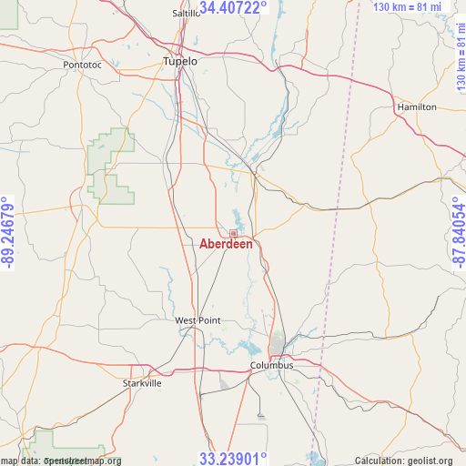
Aberdeen GPS coordinates[2]
33° 49' 30.396" North, 88° 32' 37.176" West
| Map corner | latitude | longitude |
|---|---|---|
| Upper-left | 34.40722°, | -89.24679° |
| Center: | 33.82511°, | -88.54366° |
| Lower-right: | 33.23901°, | -87.84054° |
| Map W x H: | 129.9×129.9 km | = 80.7×80.7mi |
| max Lat: | 71.29058° ⇑81.4% North |
| Aberdeen: | 33.82511° |
| min Lat: | ⇓18.6% South 19.06759° |
| min Long | Aberdeen | max Long |
| -171.73463° | -88.54366° | -66.98998° |
| W 45.1%⇐ | ⇒54.9% E |
Elevation
Elevation of Aberdeen is 71 m = 233 ft, and this is 223.8 m = 734 ft below average elevation for this country.
| Max E: |
3189 m = 10463 ft | 75.1% |
| Avg. | 294.8 m = 967 ft | |
| Aberdeen | 71 m = 233 ft | |
Min E: |
-60 m = -197 ft | 24.9% |
See also: United States elevation on elevation.city.
Geographical zone
Aberdeen is located in North temperate zone (between Tropic of Cancer and the Arctic Circle). Distance of this Northern Tropic circle is 1155.1 km =717.7 mi to South.| Distance of | km | miles | from Aberdeen |
|---|---|---|---|
| North Pole | 6246.1 | 3881.1 | to North |
| Arctic Circle | 3640.2 | 2261.9 | to North |
| Tropic Cancer | 1155.1 | 717.7 | to South |
| Equator | 3761 | 2337 | to South |


Nearby cities:
15 places around Aberdeen: (largest is in red/bold)
• Amory
18.4 km =11.4 mi,  16°
16°
• Caledonia
25.7 km =16 mi,  127°
127°
• Columbus
38.2 km =23.7 mi,  163°
163°
• Columbus Air Force Base
23.1 km =14.4 mi, 158°
• Houston
42.8 km =26.6 mi,  280°
280°
• Nettleton
30.2 km =18.8 mi,  346°
346°
• New Hamilton
13.3 km =8.3 mi,  136°
136°
• New Hope
44.5 km =27.7 mi,  153°
153°
• Okolona
27.7 km =17.2 mi,  315°
315°
• Shannon
35.9 km =22.3 mi,  334°
334°
• Smithville
30.7 km =19.1 mi,  27°
27°
• Sulligent
38.7 km =24 mi,  77°
77°
• Vernon
40.9 km =25.4 mi,  100°
100°
• Verona
44.1 km =27.4 mi,  338°
338°
• West Point
26.1 km =16.2 mi,  202°
202°
Sources, notices
• [Note1] Compared only with cities in United States existing in our database
• [Src1] Map data: © OpenStreetMap contributors (CC-BY-SA)
• [Src2] Other city data from geonames.org with taken over terms of usage.
• [Src3] Geographical zone / Annual Mean Temperature by Robert A. Rohde @ Wikipedia
