Conway geodata
Conway (North Carolina) is a populated place; located in United States in America/New_York (GMT-4) time zone. With population of 772 people, there are 18040 cities with bigger population in this country. Compared to other cities in United States, 68.3% of cities are located further ↑North; 79.7% of cities are located further ←West and 83.2% of cities have higher elevation than Conway. Note1
Administrative division(s):
- Level 1: North Carolina
- Level 2: Northampton County
- Level 3: Township of Kirby


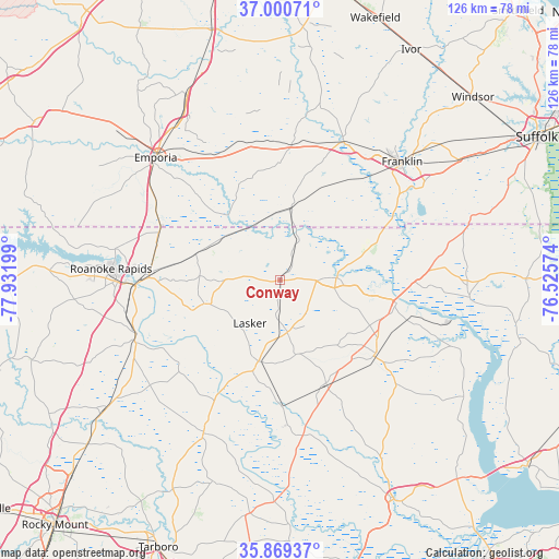
Conway GPS coordinates[2]
36° 26' 13.56" North, 77° 13' 43.896" West
| Map corner | latitude | longitude |
|---|---|---|
| Upper-left | 37.00071°, | -77.93199° |
| Center: | 36.4371°, | -77.22886° |
| Lower-right: | 35.86937°, | -76.52574° |
| Map W x H: | 125.8×125.8 km | = 78.2×78.2mi |
| max Lat: | 71.29058° ⇑68.3% North |
| Conway: | 36.4371° |
| min Lat: | ⇓31.7% South 19.06759° |
| min Long | Conway | max Long |
| -171.73463° | -77.22886° | -66.98998° |
| W 79.7%⇐ | ⇒20.3% E |
Elevation
Elevation of Conway is 34 m = 112 ft, and this is 260.8 m = 856 ft below average elevation for this country.
| Max E: |
3189 m = 10463 ft | 83.2% |
| Avg. | 294.8 m = 967 ft | |
| Conway | 34 m = 112 ft | |
Min E: |
-60 m = -197 ft | 16.8% |
See also: United States elevation on elevation.city.
Geographical zone
Conway is located in North temperate zone (between Tropic of Cancer and the Arctic Circle). Distance of this Northern Tropic circle is 1445.5 km =898.2 mi to South.| Distance of | km | miles | from Conway |
|---|---|---|---|
| North Pole | 5955.6 | 3700.6 | to North |
| Arctic Circle | 3349.7 | 2081.4 | to North |
| Tropic Cancer | 1445.5 | 898.2 | to South |
| Equator | 4051.4 | 2517.4 | to South |


Nearby cities:
15 places around Conway: (largest is in red/bold)
• Ahoskie
27.5 km =17.1 mi,  127°
127°
• Aulander
25.3 km =15.7 mi,  155°
155°
• Boykins
16.4 km =10.2 mi,  9°
9°
• Courtland
34.2 km =21.3 mi,  24°
24°
• Garysburg
29.6 km =18.4 mi,  272°
272°
• Halifax
34.5 km =21.4 mi,  249°
249°
• Jackson
18 km =11.2 mi, 252°
• Lewiston Woodville
35.2 km =21.9 mi,  172°
172°
• Murfreesboro
11.7 km =7.3 mi,  87°
87°
• Rich Square
18.8 km =11.7 mi,  195°
195°
• Seaboard
19.9 km =12.4 mi,  287°
287°
• South Weldon
33.6 km =20.9 mi, 265°
• Weldon
32.8 km =20.4 mi, 268°
• Winton
27 km =16.8 mi,  99°
99°
• Woodland
11.8 km =7.3 mi, 172°
Sources, notices
• [Note1] Compared only with cities in United States existing in our database
• [Src1] Map data: © OpenStreetMap contributors (CC-BY-SA)
• [Src2] Other city data from geonames.org with taken over terms of usage.
• [Src3] Geographical zone / Annual Mean Temperature by Robert A. Rohde @ Wikipedia
