Peletier geodata
Peletier (North Carolina) is a populated place; located in United States in America/New_York (GMT-4) time zone. With population of 651 people, there are 19169 cities with bigger population in this country. Compared to other cities in United States, 76.7% of cities are located further ↑North; 80.2% of cities are located further ←West and 93.9% of cities have higher elevation than Peletier. Note1
Administrative division(s):
- Level 1: North Carolina
- Level 2: Carteret County
- Level 3: Township of White Oak


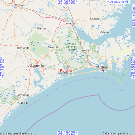
Peletier GPS coordinates[2]
34° 43' 48.576" North, 77° 5' 3.804" West
| Map corner | latitude | longitude |
|---|---|---|
| Upper-left | 35.30599°, | -77.78752° |
| Center: | 34.73016°, | -77.08439° |
| Lower-right: | 34.15029°, | -76.38127° |
| Map W x H: | 128.5×128.5 km | = 79.8×79.8mi |
| max Lat: | 71.29058° ⇑76.7% North |
| Peletier: | 34.73016° |
| min Lat: | ⇓23.3% South 19.06759° |
| min Long | Peletier | max Long |
| -171.73463° | -77.08439° | -66.98998° |
| W 80.2%⇐ | ⇒19.8% E |
Elevation
Elevation of Peletier is 10 m = 33 ft, and this is 284.8 m = 934 ft below average elevation for this country.
| Max E: |
3189 m = 10463 ft | 93.9% |
| Avg. | 294.8 m = 967 ft | |
| Peletier | 10 m = 33 ft | |
Min E: |
-60 m = -197 ft | 6.1% |
See also: United States elevation on elevation.city.
Geographical zone
Peletier is located in North temperate zone (between Tropic of Cancer and the Arctic Circle). Distance of this Northern Tropic circle is 1255.7 km =780.3 mi to South.| Distance of | km | miles | from Peletier |
|---|---|---|---|
| North Pole | 6145.4 | 3818.6 | to North |
| Arctic Circle | 3539.5 | 2199.3 | to North |
| Tropic Cancer | 1255.7 | 780.3 | to South |
| Equator | 3861.6 | 2399.5 | to South |


Nearby cities:
15 places around Peletier: (largest is in red/bold)
• Atlantic Beach
31.6 km =19.6 mi,  96°
96°
• Bogue
5.5 km =3.4 mi,  128°
128°
• Broad Creek
13.6 km =8.5 mi,  94°
94°
• Cape Carteret
4.7 km =2.9 mi,  155°
155°
• Cedar Point
4.8 km =3 mi,  166°
166°
• Emerald Isle
13.5 km =8.4 mi,  115°
115°
• Havelock
23.5 km =14.6 mi,  45°
45°
• Jacksonville
31.7 km =19.7 mi,  274°
274°
• Maysville
23.6 km =14.7 mi,  325°
325°
• Neuse Forest
28.9 km =18 mi,  26°
26°
• Newport
21.5 km =13.4 mi,  73°
73°
• Pine Knoll Shores
25 km =15.5 mi, 98°
• Piney Green
21.6 km =13.4 mi, 265°
• Pumpkin Center
27.2 km =16.9 mi,  284°
284°
• Swansboro
5.7 km =3.5 mi,  213°
213°
Sources, notices
• [Note1] Compared only with cities in United States existing in our database
• [Src1] Map data: © OpenStreetMap contributors (CC-BY-SA)
• [Src2] Other city data from geonames.org with taken over terms of usage.
• [Src3] Geographical zone / Annual Mean Temperature by Robert A. Rohde @ Wikipedia
