Kirkersville geodata
Kirkersville (Ohio) is a populated place; located in United States in America/New_York (GMT-4) time zone. With population of 541 people, there are 20378 cities with bigger population in this country. Compared to other cities in United States, 53.2% of cities are located further ↓South; 63.4% of cities are located further ←West and 69.3% of cities have lower elevation than Kirkersville. Note1


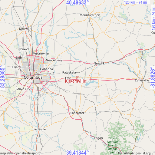
Kirkersville GPS coordinates[2]
39° 57' 34.236" North, 82° 35' 44.592" West
| Map corner | latitude | longitude |
|---|---|---|
| Upper-left | 40.49633°, | -83.29885° |
| Center: | 39.95951°, | -82.59572° |
| Lower-right: | 39.41844°, | -81.8926° |
| Map W x H: | 119.9×119.8 km | = 74.5×74.4mi |
| max Lat: | 71.29058° ⇑46.8% North |
| Kirkersville: | 39.95951° |
| min Lat: | ⇓53.2% South 19.06759° |
| min Long | Kirkersville | max Long |
| -171.73463° | -82.59572° | -66.98998° |
| W 63.4%⇐ | ⇒36.6% E |
Elevation
Elevation of Kirkersville is 282 m = 925 ft, and this is 12.8 m = 42 ft below average elevation for this country.
| Max E: |
3189 m = 10463 ft | 30.7% |
| Avg. | 294.8 m = 967 ft | |
| Kirkersville | 282 m = 925 ft | |
Min E: |
-60 m = -197 ft | 69.3% |
See also: United States elevation on elevation.city.
Geographical zone
Kirkersville is located in North temperate zone (between Tropic of Cancer and the Arctic Circle). Distance of this Northern Tropic circle is 1837.2 km =1141.6 mi to South.| Distance of | km | miles | from Kirkersville |
|---|---|---|---|
| North Pole | 5564 | 3457.3 | to North |
| Arctic Circle | 2958.1 | 1838.1 | to North |
| Tropic Cancer | 1837.2 | 1141.6 | to South |
| Equator | 4443.1 | 2760.8 | to South |


Nearby cities:
15 places around Kirkersville: (largest is in red/bold)
• Alexandria
14.5 km =9 mi,  354°
354°
• Baltimore
12.7 km =7.9 mi,  181°
181°
• Beechwood Trails
8.5 km =5.3 mi,  326°
326°
• Buckeye Lake
10.9 km =6.8 mi,  105°
105°
• Etna
7.3 km =4.5 mi,  268°
268°
• Fairfield Beach
11.4 km =7.1 mi,  115°
115°
• Granville
13.7 km =8.5 mi,  28°
28°
• Granville South
11.3 km =7 mi,  24°
24°
• Harbor Hills
13.9 km =8.6 mi,  100°
100°
• Heath
14.7 km =9.1 mi,  61°
61°
• Hebron
8.9 km =5.5 mi,  88°
88°
• Millersport
8.4 km =5.2 mi,  141°
141°
• Pataskala
7.8 km =4.8 mi,  300°
300°
• Pickerington
15.8 km =9.8 mi,  238°
238°
• Thurston
13.9 km =8.6 mi,  162°
162°
Sources, notices
• [Note1] Compared only with cities in United States existing in our database
• [Src1] Map data: © OpenStreetMap contributors (CC-BY-SA)
• [Src2] Other city data from geonames.org with taken over terms of usage.
• [Src3] Geographical zone / Annual Mean Temperature by Robert A. Rohde @ Wikipedia
