Maineville geodata
Maineville (Ohio) is a populated place; located in United States in America/New_York (GMT-4) time zone. With population of 979 people, there are 16420 cities with bigger population in this country. Compared to other cities in United States, 52.1% of cities are located further ↑North; 58.6% of cities are located further ←West and 61.2% of cities have lower elevation than Maineville. Note1


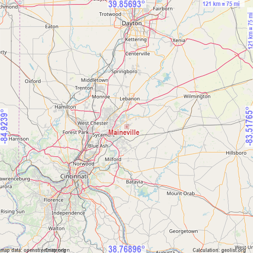
Maineville GPS coordinates[2]
39° 18' 54.216" North, 84° 13' 14.772" West
| Map corner | latitude | longitude |
|---|---|---|
| Upper-left | 39.85693°, | -84.9239° |
| Center: | 39.31506°, | -84.22077° |
| Lower-right: | 38.76896°, | -83.51765° |
| Map W x H: | 121×121 km | = 75.2×75.2mi |
| max Lat: | 71.29058° ⇑52.1% North |
| Maineville: | 39.31506° |
| min Lat: | ⇓47.9% South 19.06759° |
| min Long | Maineville | max Long |
| -171.73463° | -84.22077° | -66.98998° |
| W 58.6%⇐ | ⇒41.4% E |
Elevation
Elevation of Maineville is 245 m = 804 ft, and this is 49.8 m = 163 ft below average elevation for this country.
| Max E: |
3189 m = 10463 ft | 38.8% |
| Avg. | 294.8 m = 967 ft | |
| Maineville | 245 m = 804 ft | |
Min E: |
-60 m = -197 ft | 61.2% |
See also: United States elevation on elevation.city.
Geographical zone
Maineville is located in North temperate zone (between Tropic of Cancer and the Arctic Circle). Distance of this Northern Tropic circle is 1765.5 km =1097 mi to South.| Distance of | km | miles | from Maineville |
|---|---|---|---|
| North Pole | 5635.6 | 3501.8 | to North |
| Arctic Circle | 3029.7 | 1882.6 | to North |
| Tropic Cancer | 1765.5 | 1097 | to South |
| Equator | 4371.4 | 2716.3 | to South |


Nearby cities:
15 places around Maineville: (largest is in red/bold)
• Goshen
10.4 km =6.5 mi,  150°
150°
• Highpoint
11.5 km =7.1 mi,  255°
255°
• Kings Mills
5.1 km =3.2 mi,  332°
332°
• Landen
5.4 km =3.4 mi,  266°
266°
• Lebanon
13.5 km =8.4 mi,  6°
6°
• Loveland
6.3 km =3.9 mi,  215°
215°
• Loveland Park
4 km =2.5 mi,  245°
245°
• Mason
9.2 km =5.7 mi,  303°
303°
• Montgomery
15 km =9.3 mi,  229°
229°
• Morrow
9.2 km =5.7 mi,  61°
61°
• Mount Repose
12.7 km =7.9 mi,  181°
181°
• Mulberry
13.7 km =8.5 mi,  187°
187°
• Sixteen Mile Stand
10.3 km =6.4 mi,  242°
242°
• South Lebanon
6.2 km =3.9 mi, 5°
• Wetherington
14.5 km =9 mi,  291°
291°
Sources, notices
• [Note1] Compared only with cities in United States existing in our database
• [Src1] Map data: © OpenStreetMap contributors (CC-BY-SA)
• [Src2] Other city data from geonames.org with taken over terms of usage.
• [Src3] Geographical zone / Annual Mean Temperature by Robert A. Rohde @ Wikipedia
