Miami geodata
Miami (Oklahoma) is a seat of a second-order administrative division; located in United States in America/Chicago (GMT-5) time zone. With population of 13,611 people, there are 3529 cities with bigger population in this country. Compared to other cities in United States, 66.7% of cities are located further ↑North; 70.8% of cities are located further →East and 61.7% of cities have lower elevation than Miami. Note1


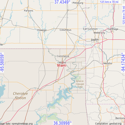
Miami GPS coordinates[2]
36° 52' 28.236" North, 94° 52' 38.856" West
| Map corner | latitude | longitude |
|---|---|---|
| Upper-left | 37.4349°, | -95.58059° |
| Center: | 36.87451°, | -94.87746° |
| Lower-right: | 36.30998°, | -94.17434° |
| Map W x H: | 125.1×125.1 km | = 77.7×77.7mi |
| max Lat: | 71.29058° ⇑66.7% North |
| Miami: | 36.87451° |
| min Lat: | ⇓33.3% South 19.06759° |
| min Long | Miami | max Long |
| -171.73463° | -94.87746° | -66.98998° |
| W 29.2%⇐ | ⇒70.8% E |
Elevation
Elevation of Miami is 247 m = 810 ft, and this is 47.8 m = 157 ft below average elevation for this country.
| Max E: |
3189 m = 10463 ft | 38.3% |
| Avg. | 294.8 m = 967 ft | |
| Miami | 247 m = 810 ft | |
Min E: |
-60 m = -197 ft | 61.7% |
See also: United States elevation on elevation.city.
Geographical zone
Miami is located in North temperate zone (between Tropic of Cancer and the Arctic Circle). Distance of this Northern Tropic circle is 1494.1 km =928.4 mi to South.| Distance of | km | miles | from Miami |
|---|---|---|---|
| North Pole | 5907 | 3670.4 | to North |
| Arctic Circle | 3301.1 | 2051.2 | to North |
| Tropic Cancer | 1494.1 | 928.4 | to South |
| Equator | 4100.1 | 2547.7 | to South |


Nearby cities:
15 places around Miami: (largest is in red/bold)
• Afton
21.5 km =13.4 mi,  200°
200°
• Baxter Springs
20.8 km =12.9 mi,  37°
37°
• Bernice
29 km =18 mi,  187°
187°
• Chetopa
26.2 km =16.3 mi,  313°
313°
• Columbus
32.9 km =20.4 mi,  5°
5°
• Commerce
6.6 km =4.1 mi,  3°
3°
• Copeland
24.7 km =15.3 mi,  169°
169°
• Fairland
14 km =8.7 mi, 168°
• Galena
30.8 km =19.1 mi, 43°
• Grove
32.7 km =20.3 mi,  162°
162°
• Loma Linda
28.9 km =18 mi,  63°
63°
• Quapaw
11.9 km =7.4 mi, 41°
• Riverton
27.1 km =16.8 mi,  34°
34°
• Seneca
24 km =14.9 mi,  98°
98°
• Welch
19.4 km =12.1 mi,  269°
269°
Sources, notices
• [Note1] Compared only with cities in United States existing in our database
• [Src1] Map data: © OpenStreetMap contributors (CC-BY-SA)
• [Src2] Other city data from geonames.org with taken over terms of usage.
• [Src3] Geographical zone / Annual Mean Temperature by Robert A. Rohde @ Wikipedia
