Quinton geodata
Quinton (Oklahoma) is a populated place; located in United States in America/Chicago (GMT-5) time zone. With population of 1,009 people, there are 16228 cities with bigger population in this country. Compared to other cities in United States, 74.7% of cities are located further ↑North; 72% of cities are located further →East and 52.8% of cities have higher elevation than Quinton. Note1


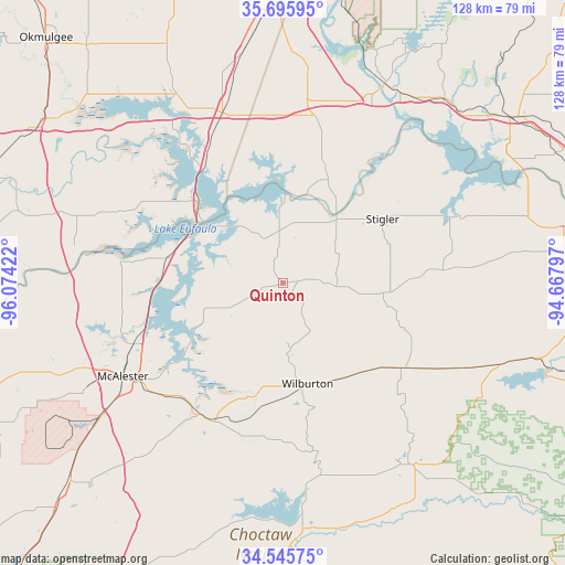
Quinton GPS coordinates[2]
35° 7' 22.368" North, 95° 22' 15.924" West
| Map corner | latitude | longitude |
|---|---|---|
| Upper-left | 35.69595°, | -96.07422° |
| Center: | 35.12288°, | -95.37109° |
| Lower-right: | 34.54575°, | -94.66797° |
| Map W x H: | 127.9×127.9 km | = 79.5×79.5mi |
| max Lat: | 71.29058° ⇑74.7% North |
| Quinton: | 35.12288° |
| min Lat: | ⇓25.3% South 19.06759° |
| min Long | Quinton | max Long |
| -171.73463° | -95.37109° | -66.98998° |
| W 28%⇐ | ⇒72% E |
Elevation
Elevation of Quinton is 188 m = 617 ft, and this is 106.8 m = 350 ft below average elevation for this country.
| Max E: |
3189 m = 10463 ft | 52.8% |
| Avg. | 294.8 m = 967 ft | |
| Quinton | 188 m = 617 ft | |
Min E: |
-60 m = -197 ft | 47.2% |
See also: United States elevation on elevation.city.
Geographical zone
Quinton is located in North temperate zone (between Tropic of Cancer and the Arctic Circle). Distance of this Northern Tropic circle is 1299.4 km =807.4 mi to South.| Distance of | km | miles | from Quinton |
|---|---|---|---|
| North Pole | 6101.8 | 3791.5 | to North |
| Arctic Circle | 3495.9 | 2172.3 | to North |
| Tropic Cancer | 1299.4 | 807.4 | to South |
| Equator | 3905.3 | 2426.6 | to South |


Nearby cities:
15 places around Quinton: (largest is in red/bold)
• Checotah
41 km =25.5 mi,  340°
340°
• Eufaula
26.5 km =16.5 mi,  313°
313°
• Haileyville
35.5 km =22.1 mi,  212°
212°
• Hartshorne
35.2 km =21.9 mi, 208°
• Keota
43.4 km =27 mi,  70°
70°
• Krebs
38.1 km =23.7 mi,  235°
235°
• Longtown
18.7 km =11.6 mi,  316°
316°
• McAlester
42 km =26.1 mi, 239°
• McCurtain
36.5 km =22.7 mi,  85°
85°
• Porum
27.7 km =17.2 mi,  20°
20°
• Red Oak
32.7 km =20.3 mi,  125°
125°
• Stigler
26.8 km =16.7 mi,  57°
57°
• Texanna
25.7 km =16 mi,  346°
346°
• Warner
41.7 km =25.9 mi,  8°
8°
• Wilburton
23.4 km =14.5 mi,  166°
166°
Sources, notices
• [Note1] Compared only with cities in United States existing in our database
• [Src1] Map data: © OpenStreetMap contributors (CC-BY-SA)
• [Src2] Other city data from geonames.org with taken over terms of usage.
• [Src3] Geographical zone / Annual Mean Temperature by Robert A. Rohde @ Wikipedia
