Uniontown geodata
Uniontown (Pennsylvania) is a seat of a second-order administrative division; located in United States in America/New_York (GMT-4) time zone. With population of 9,990 people, there are 4468 cities with bigger population in this country. Compared to other cities in United States, 52.5% of cities are located further ↓South; 74.4% of cities are located further ←West and 76.8% of cities have lower elevation than Uniontown. Note1
Administrative division(s):
- Level 1: Pennsylvania
- Level 2: Fayette County
- Level 3: City of Uniontown


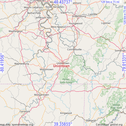
Uniontown GPS coordinates[2]
39° 54' 0.288" North, 79° 42' 59.148" West
| Map corner | latitude | longitude |
|---|---|---|
| Upper-left | 40.43737°, | -80.41956° |
| Center: | 39.90008°, | -79.71643° |
| Lower-right: | 39.35855°, | -79.01331° |
| Map W x H: | 120×120 km | = 74.6×74.6mi |
| max Lat: | 71.29058° ⇑47.5% North |
| Uniontown: | 39.90008° |
| min Lat: | ⇓52.5% South 19.06759° |
| min Long | Uniontown | max Long |
| -171.73463° | -79.71643° | -66.98998° |
| W 74.4%⇐ | ⇒25.6% E |
Elevation
Elevation of Uniontown is 326 m = 1070 ft, and this is 31.2 m = 102 ft above average elevation for this country.
| Max E: |
3189 m = 10463 ft | 23.2% |
| Uniontown | 326 m 1070 ft | |
| Avg. | 294.8 m = 967 ft | |
Min E: |
-60 m = -197 ft | 76.8% |
See also: United States elevation on elevation.city.
Geographical zone
Uniontown is located in North temperate zone (between Tropic of Cancer and the Arctic Circle). Distance of this Northern Tropic circle is 1830.6 km =1137.5 mi to South.| Distance of | km | miles | from Uniontown |
|---|---|---|---|
| North Pole | 5570.6 | 3461.4 | to North |
| Arctic Circle | 2964.7 | 1842.2 | to North |
| Tropic Cancer | 1830.6 | 1137.5 | to South |
| Equator | 4436.5 | 2756.7 | to South |


Nearby cities:
15 places around Uniontown: (largest is in red/bold)
• Allison
16 km =9.9 mi,  308°
308°
• Dunbar
12.3 km =7.6 mi,  45°
45°
• East Uniontown
1.6 km =1 mi,  91°
91°
• Fairchance
9 km =5.6 mi,  201°
201°
• Hopwood
2.8 km =1.7 mi,  154°
154°
• Leith-Hatfield
2.8 km =1.7 mi,  206°
206°
• Lemont Furnace
4.3 km =2.7 mi,  68°
68°
• New Salem
10.5 km =6.5 mi,  284°
284°
• Oliver
2.1 km =1.3 mi,  356°
356°
• Republic
15.3 km =9.5 mi,  296°
296°
• Rowes Run
14.9 km =9.3 mi,  324°
324°
• Smithfield
13.3 km =8.3 mi,  215°
215°
• Smock
12.3 km =7.6 mi,  332°
332°
• South Connellsville
15.5 km =9.6 mi, 45°
• South Uniontown
2.7 km =1.7 mi,  252°
252°
Sources, notices
• [Note1] Compared only with cities in United States existing in our database
• [Src1] Map data: © OpenStreetMap contributors (CC-BY-SA)
• [Src2] Other city data from geonames.org with taken over terms of usage.
• [Src3] Geographical zone / Annual Mean Temperature by Robert A. Rohde @ Wikipedia
