Balcones Heights geodata
Balcones Heights (Texas) is a populated place; located in United States in America/Chicago (GMT-5) time zone. With population of 3,254 people, there are 9221 cities with bigger population in this country. Compared to other cities in United States, 94.6% of cities are located further ↑North; 79.4% of cities are located further →East and 64.1% of cities have lower elevation than Balcones Heights. Note1


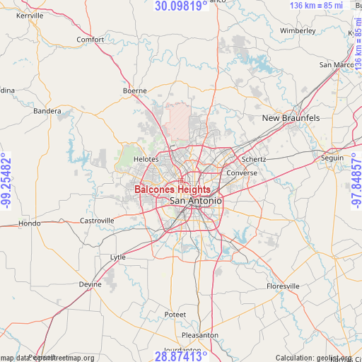
Balcones Heights GPS coordinates[2]
29° 29' 16.836" North, 98° 33' 6.084" West
| Map corner | latitude | longitude |
|---|---|---|
| Upper-left | 30.09819°, | -99.25482° |
| Center: | 29.48801°, | -98.55169° |
| Lower-right: | 28.87413°, | -97.84857° |
| Map W x H: | 136.1×136.1 km | = 84.6×84.6mi |
| max Lat: | 71.29058° ⇑94.6% North |
| Balcones Heights: | 29.48801° |
| min Lat: | ⇓5.4% South 19.06759° |
| min Long | Balcones Height | max Long |
| -171.73463° | -98.55169° | -66.98998° |
| W 20.6%⇐ | ⇒79.4% E |
Elevation
Elevation of Balcones Heights is 258 m = 846 ft, and this is 36.8 m = 121 ft below average elevation for this country.
| Max E: |
3189 m = 10463 ft | 35.9% |
| Avg. | 294.8 m = 967 ft | |
| Balcones Heights | 258 m = 846 ft | |
Min E: |
-60 m = -197 ft | 64.1% |
See also: United States elevation on elevation.city.
Geographical zone
Balcones Heights is located in North temperate zone (between Tropic of Cancer and the Arctic Circle). Distance of this Northern Tropic circle is 672.8 km =418.1 mi to South.| Distance of | km | miles | from Balcones Heights |
|---|---|---|---|
| North Pole | 6728.3 | 4180.8 | to North |
| Arctic Circle | 4122.4 | 2561.5 | to North |
| Tropic Cancer | 672.8 | 418.1 | to South |
| Equator | 3278.8 | 2037.4 | to South |


Nearby cities:
15 places around Balcones Heights: (largest is in red/bold)
• Alamo Heights
8.3 km =5.2 mi,  92°
92°
• Castle Hills
5.2 km =3.2 mi,  41°
41°
• Cross Mountain
20.4 km =12.7 mi,  329°
329°
• Grey Forest
18.9 km =11.7 mi,  318°
318°
• Helotes
16.7 km =10.4 mi,  306°
306°
• Hill Country Village
12 km =7.5 mi,  29°
29°
• Hollywood Park
14 km =8.7 mi, 26°
• Kirby
16.3 km =10.1 mi,  99°
99°
• Lackland Air Force Base
13 km =8.1 mi,  209°
209°
• Leon Valley
6.5 km =4 mi,  277°
277°
• Olmos Park
6.3 km =3.9 mi, 99°
• San Antonio
9.1 km =5.7 mi,  141°
141°
• Shavano Park
10.8 km =6.7 mi,  359°
359°
• Terrell Hills
9.9 km =6.2 mi, 98°
• Windcrest
16.9 km =10.5 mi,  79°
79°
Sources, notices
• [Note1] Compared only with cities in United States existing in our database
• [Src1] Map data: © OpenStreetMap contributors (CC-BY-SA)
• [Src2] Other city data from geonames.org with taken over terms of usage.
• [Src3] Geographical zone / Annual Mean Temperature by Robert A. Rohde @ Wikipedia
