Escobares geodata
Escobares (Texas) is a populated place; located in United States in America/Chicago (GMT-5) time zone. With population of 2,451 people, there are 10740 cities with bigger population in this country. Compared to other cities in United States, 98.1% of cities are located further ↑North; 79.9% of cities are located further →East and 77.9% of cities have higher elevation than Escobares. Note1


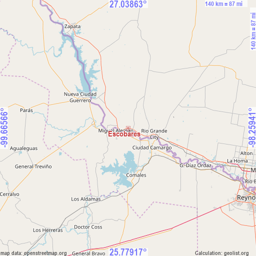
Escobares GPS coordinates[2]
26° 24' 38.232" North, 98° 57' 45.108" West
| Map corner | latitude | longitude |
|---|---|---|
| Upper-left | 27.03863°, | -99.66566° |
| Center: | 26.41062°, | -98.96253° |
| Lower-right: | 25.77917°, | -98.25941° |
| Map W x H: | 140×140 km | = 87×87mi |
| max Lat: | 71.29058° ⇑98.1% North |
| Escobares: | 26.41062° |
| min Lat: | ⇓1.9% South 19.06759° |
| min Long | Escobares | max Long |
| -171.73463° | -98.96253° | -66.98998° |
| W 20.1%⇐ | ⇒79.9% E |
Elevation
Elevation of Escobares is 56 m = 184 ft, and this is 238.8 m = 783 ft below average elevation for this country.
| Max E: |
3189 m = 10463 ft | 77.9% |
| Avg. | 294.8 m = 967 ft | |
| Escobares | 56 m = 184 ft | |
Min E: |
-60 m = -197 ft | 22.1% |
See also: United States elevation on elevation.city.
Geographical zone
Escobares is located in North temperate zone (between Tropic of Cancer and the Arctic Circle). Distance of this Northern Tropic circle is 330.7 km =205.5 mi to South.| Distance of | km | miles | from Escobares |
|---|---|---|---|
| North Pole | 7070.5 | 4393.4 | to North |
| Arctic Circle | 4464.6 | 2774.2 | to North |
| Tropic Cancer | 330.7 | 205.5 | to South |
| Equator | 2936.6 | 1824.7 | to South |


Nearby cities:
15 places around Escobares: (largest is in red/bold)
• Alto Bonito
34.1 km =21.2 mi,  109°
109°
• Alto Bonito Colonia
34.2 km =21.3 mi, 110°
• B and E Colonia
21.6 km =13.4 mi, 106°
• Garza-Salinas II
21.3 km =13.2 mi, 107°
• La Grulla
35.1 km =21.8 mi,  116°
116°
• La Joya
51.3 km =31.9 mi, 110°
• La Puerta
22.9 km =14.2 mi, 108°
• Las Lomas
19.3 km =12 mi, 105°
• Penitas
55.3 km =34.4 mi, 111°
• Rio Grande City
14.6 km =9.1 mi,  103°
103°
• Roma
5.3 km =3.3 mi,  263°
263°
• Roma-Los Saenz
5.3 km =3.3 mi, 263°
• Siesta Shores
57.6 km =35.8 mi,  329°
329°
• Sullivan City
42.4 km =26.3 mi, 110°
• West Alto Bonito Colonia
31.7 km =19.7 mi, 109°
Sources, notices
• [Note1] Compared only with cities in United States existing in our database
• [Src1] Map data: © OpenStreetMap contributors (CC-BY-SA)
• [Src2] Other city data from geonames.org with taken over terms of usage.
• [Src3] Geographical zone / Annual Mean Temperature by Robert A. Rohde @ Wikipedia
