Haslet geodata
Haslet (Texas) is a populated place; located in United States in America/Chicago (GMT-5) time zone. With population of 1,786 people, there are 12596 cities with bigger population in this country. Compared to other cities in United States, 85.2% of cities are located further ↑North; 76.7% of cities are located further →East and 54.9% of cities have lower elevation than Haslet. Note1


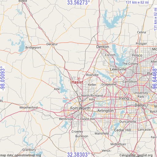
Haslet GPS coordinates[2]
32° 58' 29.46" North, 97° 20' 52.08" West
| Map corner | latitude | longitude |
|---|---|---|
| Upper-left | 33.56273°, | -98.05093° |
| Center: | 32.97485°, | -97.3478° |
| Lower-right: | 32.38303°, | -96.64468° |
| Map W x H: | 131.2×131.2 km | = 81.5×81.5mi |
| max Lat: | 71.29058° ⇑85.2% North |
| Haslet: | 32.97485° |
| min Lat: | ⇓14.8% South 19.06759° |
| min Long | Haslet | max Long |
| -171.73463° | -97.3478° | -66.98998° |
| W 23.3%⇐ | ⇒76.7% E |
Elevation
Elevation of Haslet is 218 m = 715 ft, and this is 76.8 m = 252 ft below average elevation for this country.
| Max E: |
3189 m = 10463 ft | 45.1% |
| Avg. | 294.8 m = 967 ft | |
| Haslet | 218 m = 715 ft | |
Min E: |
-60 m = -197 ft | 54.9% |
See also: United States elevation on elevation.city.
Geographical zone
Haslet is located in North temperate zone (between Tropic of Cancer and the Arctic Circle). Distance of this Northern Tropic circle is 1060.5 km =659 mi to South.| Distance of | km | miles | from Haslet |
|---|---|---|---|
| North Pole | 6340.6 | 3939.9 | to North |
| Arctic Circle | 3734.7 | 2320.6 | to North |
| Tropic Cancer | 1060.5 | 659 | to South |
| Equator | 3666.5 | 2278.3 | to South |


Nearby cities:
15 places around Haslet: (largest is in red/bold)
• Blue Mound
13.2 km =8.2 mi,  176°
176°
• Eagle Mountain
12.8 km =8 mi,  224°
224°
• Justin
13.1 km =8.1 mi,  21°
21°
• Keller
10 km =6.2 mi,  116°
116°
• Marshall Creek
13.8 km =8.6 mi,  70°
70°
• New Fairview
16.6 km =10.3 mi,  326°
326°
• Newark
13.1 km =8.1 mi,  282°
282°
• Pecan Acres
11.9 km =7.4 mi,  267°
267°
• Pelican Bay
17 km =10.6 mi,  249°
249°
• Rhome
14.5 km =9 mi,  307°
307°
• Roanoke
11.8 km =7.3 mi, 74°
• Saginaw
12.8 km =8 mi,  186°
186°
• Trophy Club
15.5 km =9.6 mi,  80°
80°
• Watauga
15.6 km =9.7 mi,  146°
146°
• Westlake
14.4 km =8.9 mi, 82°
Sources, notices
• [Note1] Compared only with cities in United States existing in our database
• [Src1] Map data: © OpenStreetMap contributors (CC-BY-SA)
• [Src2] Other city data from geonames.org with taken over terms of usage.
• [Src3] Geographical zone / Annual Mean Temperature by Robert A. Rohde @ Wikipedia
