Needville geodata
Needville (Texas) is a populated place; located in United States in America/Chicago (GMT-5) time zone. With population of 3,063 people, there are 9538 cities with bigger population in this country. Compared to other cities in United States, 94.8% of cities are located further ↑North; 73.1% of cities are located further →East and 84.1% of cities have higher elevation than Needville. Note1


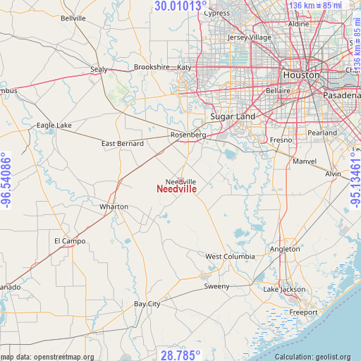
Needville GPS coordinates[2]
29° 23' 57.876" North, 95° 50' 15.828" West
| Map corner | latitude | longitude |
|---|---|---|
| Upper-left | 30.01013°, | -96.54086° |
| Center: | 29.39941°, | -95.83773° |
| Lower-right: | 28.785°, | -95.13461° |
| Map W x H: | 136.2×136.2 km | = 84.6×84.6mi |
| max Lat: | 71.29058° ⇑94.8% North |
| Needville: | 29.39941° |
| min Lat: | ⇓5.2% South 19.06759° |
| min Long | Needville | max Long |
| -171.73463° | -95.83773° | -66.98998° |
| W 26.9%⇐ | ⇒73.1% E |
Elevation
Elevation of Needville is 31 m = 102 ft, and this is 263.8 m = 865 ft below average elevation for this country.
| Max E: |
3189 m = 10463 ft | 84.1% |
| Avg. | 294.8 m = 967 ft | |
| Needville | 31 m = 102 ft | |
Min E: |
-60 m = -197 ft | 15.9% |
See also: United States elevation on elevation.city.
Geographical zone
Needville is located in North temperate zone (between Tropic of Cancer and the Arctic Circle). Distance of this Northern Tropic circle is 663 km =412 mi to South.| Distance of | km | miles | from Needville |
|---|---|---|---|
| North Pole | 6738.2 | 4186.9 | to North |
| Arctic Circle | 4132.3 | 2567.7 | to North |
| Tropic Cancer | 663 | 412 | to South |
| Equator | 3268.9 | 2031.2 | to South |


Nearby cities:
15 places around Needville: (largest is in red/bold)
• Beasley
13.4 km =8.3 mi,  324°
324°
• Boling
18.2 km =11.3 mi,  214°
214°
• Cumings
20.2 km =12.6 mi,  10°
10°
• Damon
15.7 km =9.8 mi,  140°
140°
• East Bernard
26.9 km =16.7 mi,  302°
302°
• Fairchilds
6.6 km =4.1 mi,  57°
57°
• Fulshear
32.9 km =20.4 mi,  349°
349°
• Greatwood
23.3 km =14.5 mi,  42°
42°
• New Territory
26.4 km =16.4 mi, 35°
• Pecan Grove
27.2 km =16.9 mi,  22°
22°
• Pleak
10.4 km =6.5 mi, 16°
• Richmond
21.6 km =13.4 mi, 20°
• Rosenberg
17.8 km =11.1 mi, 9°
• Sugar Land
31.4 km =19.5 mi, 38°
• Wharton
27.5 km =17.1 mi,  249°
249°
Sources, notices
• [Note1] Compared only with cities in United States existing in our database
• [Src1] Map data: © OpenStreetMap contributors (CC-BY-SA)
• [Src2] Other city data from geonames.org with taken over terms of usage.
• [Src3] Geographical zone / Annual Mean Temperature by Robert A. Rohde @ Wikipedia
