Santa Rosa geodata
Santa Rosa (Texas) is a populated place; located in United States in America/Chicago (GMT-5) time zone. With population of 2,876 people, there are 9868 cities with bigger population in this country. Compared to other cities in United States, 98.3% of cities are located further ↑North; 78.1% of cities are located further →East and 88.2% of cities have higher elevation than Santa Rosa. Note1


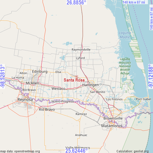
Santa Rosa GPS coordinates[2]
26° 15' 24.264" North, 97° 49' 30" West
| Map corner | latitude | longitude |
|---|---|---|
| Upper-left | 26.8856°, | -98.52813° |
| Center: | 26.25674°, | -97.825° |
| Lower-right: | 25.62446°, | -97.12188° |
| Map W x H: | 140.2×140.2 km | = 87.1×87.1mi |
| max Lat: | 71.29058° ⇑98.3% North |
| Santa Rosa: | 26.25674° |
| min Lat: | ⇓1.7% South 19.06759° |
| min Long | Santa Rosa | max Long |
| -171.73463° | -97.825° | -66.98998° |
| W 21.9%⇐ | ⇒78.1% E |
Elevation
Elevation of Santa Rosa is 20 m = 66 ft, and this is 274.8 m = 902 ft below average elevation for this country.
| Max E: |
3189 m = 10463 ft | 88.2% |
| Avg. | 294.8 m = 967 ft | |
| Santa Rosa | 20 m = 66 ft | |
Min E: |
-60 m = -197 ft | 11.8% |
See also: United States elevation on elevation.city.
Geographical zone
Santa Rosa is located in North temperate zone (between Tropic of Cancer and the Arctic Circle). Distance of this Northern Tropic circle is 313.6 km =194.9 mi to South.| Distance of | km | miles | from Santa Rosa |
|---|---|---|---|
| North Pole | 7087.6 | 4404 | to North |
| Arctic Circle | 4481.7 | 2784.8 | to North |
| Tropic Cancer | 313.6 | 194.9 | to South |
| Equator | 2919.5 | 1814.1 | to South |


Nearby cities:
15 places around Santa Rosa: (largest is in red/bold)
• Bixby
12 km =7.5 mi,  193°
193°
• Combes
9.1 km =5.7 mi,  95°
95°
• Edcouch
14.1 km =8.8 mi,  287°
287°
• Harlingen
14.8 km =9.2 mi,  119°
119°
• Heidelberg
8.6 km =5.3 mi,  219°
219°
• Indian Hills
10.3 km =6.4 mi,  241°
241°
• La Feria
10.9 km =6.8 mi,  179°
179°
• La Villa
11.3 km =7 mi, 294°
• Las Palmas II
10.7 km =6.6 mi,  125°
125°
• Mercedes
14.8 km =9.2 mi, 216°
• Mila Doce
13.8 km =8.6 mi,  255°
255°
• Palm Valley
9.3 km =5.8 mi, 130°
• Primera
7.5 km =4.7 mi, 117°
• Sebastian
10.2 km =6.3 mi,  19°
19°
• Solis
10.7 km =6.6 mi, 189°
Sources, notices
• [Note1] Compared only with cities in United States existing in our database
• [Src1] Map data: © OpenStreetMap contributors (CC-BY-SA)
• [Src2] Other city data from geonames.org with taken over terms of usage.
• [Src3] Geographical zone / Annual Mean Temperature by Robert A. Rohde @ Wikipedia
