Van Vleck geodata
Van Vleck (Texas) is a populated place; located in United States in America/Chicago (GMT-5) time zone. With population of 1,844 people, there are 12395 cities with bigger population in this country. Compared to other cities in United States, 95.2% of cities are located further ↑North; 73.2% of cities are located further →East and 89.5% of cities have higher elevation than Van Vleck. Note1


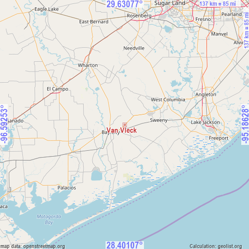
Van Vleck GPS coordinates[2]
29° 1' 3.9" North, 95° 53' 21.84" West
| Map corner | latitude | longitude |
|---|---|---|
| Upper-left | 29.63077°, | -96.59253° |
| Center: | 29.01775°, | -95.8894° |
| Lower-right: | 28.40107°, | -95.18628° |
| Map W x H: | 136.7×136.7 km | = 84.9×84.9mi |
| max Lat: | 71.29058° ⇑95.2% North |
| Van Vleck: | 29.01775° |
| min Lat: | ⇓4.8% South 19.06759° |
| min Long | Van Vleck | max Long |
| -171.73463° | -95.8894° | -66.98998° |
| W 26.8%⇐ | ⇒73.2% E |
Elevation
Elevation of Van Vleck is 17 m = 56 ft, and this is 277.8 m = 911 ft below average elevation for this country.
| Max E: |
3189 m = 10463 ft | 89.5% |
| Avg. | 294.8 m = 967 ft | |
| Van Vleck | 17 m = 56 ft | |
Min E: |
-60 m = -197 ft | 10.5% |
See also: United States elevation on elevation.city.
Geographical zone
Van Vleck is located in North temperate zone (between Tropic of Cancer and the Arctic Circle). Distance of this Northern Tropic circle is 620.6 km =385.6 mi to South.| Distance of | km | miles | from Van Vleck |
|---|---|---|---|
| North Pole | 6780.6 | 4213.3 | to North |
| Arctic Circle | 4174.7 | 2594 | to North |
| Tropic Cancer | 620.6 | 385.6 | to South |
| Equator | 3226.5 | 2004.9 | to South |


Nearby cities:
15 places around Van Vleck: (largest is in red/bold)
• Bailey Prairie
39.9 km =24.8 mi,  68°
68°
• Bay City
8.7 km =5.4 mi,  243°
243°
• Blessing
35.9 km =22.3 mi, 243°
• Boling
27.9 km =17.3 mi,  349°
349°
• Brazoria
31.3 km =19.4 mi,  84°
84°
• Damon
33.8 km =21 mi,  26°
26°
• El Campo
42 km =26.1 mi,  298°
298°
• Holiday Lakes
42 km =26.1 mi,  59°
59°
• Jones Creek
42.6 km =26.5 mi,  97°
97°
• Markham
18.3 km =11.4 mi,  249°
249°
• Matagorda
37.1 km =23.1 mi,  191°
191°
• Sweeny
18.7 km =11.6 mi, 82°
• West Columbia
27.6 km =17.1 mi, 59°
• Wharton
38.7 km =24 mi,  327°
327°
• Wild Peach Village
25.9 km =16.1 mi, 73°
Sources, notices
• [Note1] Compared only with cities in United States existing in our database
• [Src1] Map data: © OpenStreetMap contributors (CC-BY-SA)
• [Src2] Other city data from geonames.org with taken over terms of usage.
• [Src3] Geographical zone / Annual Mean Temperature by Robert A. Rohde @ Wikipedia
