Weslaco geodata
Weslaco (Texas) is a populated place; located in United States in America/Chicago (GMT-5) time zone. With population of 39,474 people, there are 1229 cities with bigger population in this country. Compared to other cities in United States, 98.6% of cities are located further ↑North; 78.5% of cities are located further →East and 84.8% of cities have higher elevation than Weslaco. Note1


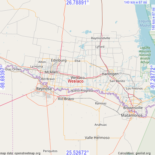
Weslaco GPS coordinates[2]
26° 9' 34.272" North, 97° 59' 27.024" West
| Map corner | latitude | longitude |
|---|---|---|
| Upper-left | 26.78891°, | -98.69397° |
| Center: | 26.15952°, | -97.99084° |
| Lower-right: | 25.52672°, | -97.28772° |
| Map W x H: | 140.3×140.3 km | = 87.2×87.2mi |
| max Lat: | 71.29058° ⇑98.6% North |
| Weslaco: | 26.15952° |
| min Lat: | ⇓1.4% South 19.06759° |
| min Long | Weslaco | max Long |
| -171.73463° | -97.99084° | -66.98998° |
| W 21.5%⇐ | ⇒78.5% E |
Elevation
Elevation of Weslaco is 29 m = 95 ft, and this is 265.8 m = 872 ft below average elevation for this country.
| Max E: |
3189 m = 10463 ft | 84.8% |
| Avg. | 294.8 m = 967 ft | |
| Weslaco | 29 m = 95 ft | |
Min E: |
-60 m = -197 ft | 15.2% |
See also: United States elevation on elevation.city.
Geographical zone
Weslaco is located in North temperate zone (between Tropic of Cancer and the Arctic Circle). Distance of this Northern Tropic circle is 302.7 km =188.1 mi to South.| Distance of | km | miles | from Weslaco |
|---|---|---|---|
| North Pole | 7098.4 | 4410.7 | to North |
| Arctic Circle | 4492.5 | 2791.5 | to North |
| Tropic Cancer | 302.7 | 188.1 | to South |
| Equator | 2908.7 | 1807.4 | to South |


Nearby cities:
15 places around Weslaco: (largest is in red/bold)
• Alamo
13.5 km =8.4 mi,  281°
281°
• Bixby
13.7 km =8.5 mi,  93°
93°
• Donna
6.2 km =3.9 mi, 281°
• Heidelberg
11.8 km =7.3 mi,  69°
69°
• Indian Hills
9.5 km =5.9 mi,  51°
51°
• Llano Grande
4 km =2.5 mi,  145°
145°
• Mercedes
7.8 km =4.8 mi,  97°
97°
• Midway North
4.1 km =2.5 mi,  320°
320°
• Midway South
2.9 km =1.8 mi,  264°
264°
• Mila Doce
8.1 km =5 mi,  23°
23°
• Olivarez
7.7 km =4.8 mi,  358°
358°
• Progreso
8.2 km =5.1 mi,  155°
155°
• Scissors
6.7 km =4.2 mi,  250°
250°
• South Alamo
11.8 km =7.3 mi,  268°
268°
• Villa Verde
3.1 km =1.9 mi,  193°
193°
Sources, notices
• [Note1] Compared only with cities in United States existing in our database
• [Src1] Map data: © OpenStreetMap contributors (CC-BY-SA)
• [Src2] Other city data from geonames.org with taken over terms of usage.
• [Src3] Geographical zone / Annual Mean Temperature by Robert A. Rohde @ Wikipedia
