Dooms geodata
Dooms (Virginia) is a populated place; located in United States in America/New_York (GMT-4) time zone. With population of 1,327 people, there are 14451 cities with bigger population in this country. Compared to other cities in United States, 61.1% of cities are located further ↑North; 76.1% of cities are located further ←West and 82.6% of cities have lower elevation than Dooms. Note1


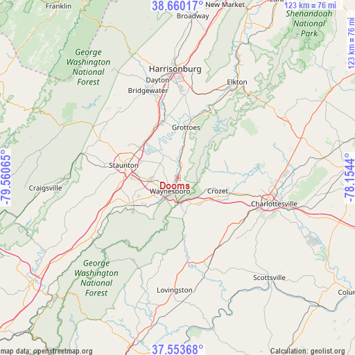
Dooms GPS coordinates[2]
38° 6' 32.472" North, 78° 51' 27.072" West
| Map corner | latitude | longitude |
|---|---|---|
| Upper-left | 38.66017°, | -79.56065° |
| Center: | 38.10902°, | -78.85752° |
| Lower-right: | 37.55368°, | -78.1544° |
| Map W x H: | 123×123 km | = 76.4×76.4mi |
| max Lat: | 71.29058° ⇑61.1% North |
| Dooms: | 38.10902° |
| min Lat: | ⇓38.9% South 19.06759° |
| min Long | Dooms | max Long |
| -171.73463° | -78.85752° | -66.98998° |
| W 76.1%⇐ | ⇒23.9% E |
Elevation
Elevation of Dooms is 384 m = 1260 ft, and this is 89.2 m = 293 ft above average elevation for this country.
| Max E: |
3189 m = 10463 ft | 17.4% |
| Dooms | 384 m 1260 ft | |
| Avg. | 294.8 m = 967 ft | |
Min E: |
-60 m = -197 ft | 82.6% |
See also: United States elevation on elevation.city.
Geographical zone
Dooms is located in North temperate zone (between Tropic of Cancer and the Arctic Circle). Distance of this Northern Tropic circle is 1631.4 km =1013.7 mi to South.| Distance of | km | miles | from Dooms |
|---|---|---|---|
| North Pole | 5769.7 | 3585.1 | to North |
| Arctic Circle | 3163.8 | 1965.9 | to North |
| Tropic Cancer | 1631.4 | 1013.7 | to South |
| Equator | 4237.3 | 2632.9 | to South |


Nearby cities:
15 places around Dooms: (largest is in red/bold)
• Crimora
5 km =3.1 mi,  7°
7°
• Crozet
14.4 km =8.9 mi,  107°
107°
• Fishersville
9.8 km =6.1 mi,  263°
263°
• Grottoes
17.8 km =11.1 mi, 8°
• Harriston
12.2 km =7.6 mi, 10°
• Jolivue
18.9 km =11.7 mi,  270°
270°
• Lyndhurst
11.7 km =7.3 mi,  220°
220°
• Mount Sidney
18.7 km =11.6 mi,  331°
331°
• New Hope
10.7 km =6.6 mi,  336°
336°
• Sherando
16.5 km =10.3 mi,  210°
210°
• Staunton
19.4 km =12.1 mi,  283°
283°
• Stuarts Draft
17.7 km =11 mi,  240°
240°
• Verona
16.8 km =10.4 mi,  308°
308°
• Waynesboro
5.3 km =3.3 mi, 211°
• Weyers Cave
20.5 km =12.7 mi,  346°
346°
Sources, notices
• [Note1] Compared only with cities in United States existing in our database
• [Src1] Map data: © OpenStreetMap contributors (CC-BY-SA)
• [Src2] Other city data from geonames.org with taken over terms of usage.
• [Src3] Geographical zone / Annual Mean Temperature by Robert A. Rohde @ Wikipedia
