Reston geodata
Reston (Virginia) is a populated place; located in United States in America/New_York (GMT-4) time zone. With population of 58,404 people, there are 780 cities with bigger population in this country. Compared to other cities in United States, 55.2% of cities are located further ↑North; 79.4% of cities are located further ←West and 69.7% of cities have higher elevation than Reston. Note1


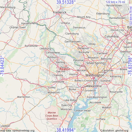
Reston GPS coordinates[2]
38° 58' 7.392" North, 77° 20' 27.96" West
| Map corner | latitude | longitude |
|---|---|---|
| Upper-left | 39.51328°, | -78.04423° |
| Center: | 38.96872°, | -77.3411° |
| Lower-right: | 38.41994°, | -76.63798° |
| Map W x H: | 121.6×121.6 km | = 75.6×75.6mi |
| max Lat: | 71.29058° ⇑55.2% North |
| Reston: | 38.96872° |
| min Lat: | ⇓44.8% South 19.06759° |
| min Long | Reston | max Long |
| -171.73463° | -77.3411° | -66.98998° |
| W 79.4%⇐ | ⇒20.6% E |
Elevation
Elevation of Reston is 102 m = 335 ft, and this is 192.8 m = 633 ft below average elevation for this country.
| Max E: |
3189 m = 10463 ft | 69.7% |
| Avg. | 294.8 m = 967 ft | |
| Reston | 102 m = 335 ft | |
Min E: |
-60 m = -197 ft | 30.3% |
See also: Reston elevation on elevation.city.
Geographical zone
Reston is located in North temperate zone (between Tropic of Cancer and the Arctic Circle). Distance of this Northern Tropic circle is 1727 km =1073.1 mi to South.| Distance of | km | miles | from Reston |
|---|---|---|---|
| North Pole | 5674.1 | 3525.7 | to North |
| Arctic Circle | 3068.3 | 1906.6 | to North |
| Tropic Cancer | 1727 | 1073.1 | to South |
| Equator | 4332.9 | 2692.3 | to South |


Nearby cities:
15 places around Reston: (largest is in red/bold)
• Countryside
10.2 km =6.3 mi,  322°
322°
• Dranesville
3.6 km =2.2 mi,  353°
353°
• Dulles Town Center
10 km =6.2 mi, 319°
• Floris
7.1 km =4.4 mi,  240°
240°
• Great Falls
5.6 km =3.5 mi,  54°
54°
• Herndon
3.9 km =2.4 mi,  271°
271°
• Lowes Island
10.2 km =6.3 mi, 354°
• Oak Grove
5.7 km =3.5 mi,  287°
287°
• Oak Hill
7.1 km =4.4 mi,  227°
227°
• Oakton
10.4 km =6.5 mi,  160°
160°
• Sterling
8.6 km =5.3 mi,  298°
298°
• Sugarland Run
8.2 km =5.1 mi,  338°
338°
• Tysons Corner
11 km =6.8 mi,  120°
120°
• Vienna
10 km =6.2 mi,  138°
138°
• Wolf Trap
5.7 km =3.5 mi, 124°
Sources, notices
• [Note1] Compared only with cities in United States existing in our database
• [Src1] Map data: © OpenStreetMap contributors (CC-BY-SA)
• [Src2] Other city data from geonames.org with taken over terms of usage.
• [Src3] Geographical zone / Annual Mean Temperature by Robert A. Rohde @ Wikipedia
