Masontown geodata
Masontown (West Virginia) is a populated place; located in United States in America/New_York (GMT-4) time zone. With population of 546 people, there are 20321 cities with bigger population in this country. Compared to other cities in United States, 50.4% of cities are located further ↑North; 74.2% of cities are located further ←West and 88.9% of cities have lower elevation than Masontown. Note1


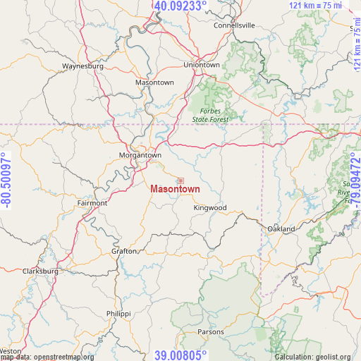
Masontown GPS coordinates[2]
39° 33' 8.316" North, 79° 47' 52.224" West
| Map corner | latitude | longitude |
|---|---|---|
| Upper-left | 40.09233°, | -80.50097° |
| Center: | 39.55231°, | -79.79784° |
| Lower-right: | 39.00805°, | -79.09472° |
| Map W x H: | 120.6×120.6 km | = 74.9×74.9mi |
| max Lat: | 71.29058° ⇑50.4% North |
| Masontown: | 39.55231° |
| min Lat: | ⇓49.6% South 19.06759° |
| min Long | Masontown | max Long |
| -171.73463° | -79.79784° | -66.98998° |
| W 74.2%⇐ | ⇒25.8% E |
Elevation
Elevation of Masontown is 551 m = 1808 ft, and this is 256.2 m = 841 ft above average elevation for this country.
| Max E: |
3189 m = 10463 ft | 11.1% |
| Masontown | 551 m 1808 ft | |
| Avg. | 294.8 m = 967 ft | |
Min E: |
-60 m = -197 ft | 88.9% |
See also: United States elevation on elevation.city.
Geographical zone
Masontown is located in North temperate zone (between Tropic of Cancer and the Arctic Circle). Distance of this Northern Tropic circle is 1791.9 km =1113.4 mi to South.| Distance of | km | miles | from Masontown |
|---|---|---|---|
| North Pole | 5609.3 | 3485.5 | to North |
| Arctic Circle | 3003.4 | 1866.2 | to North |
| Tropic Cancer | 1791.9 | 1113.4 | to South |
| Equator | 4397.8 | 2732.7 | to South |


Nearby cities:
15 places around Masontown: (largest is in red/bold)
• Bobtown
28 km =17.4 mi,  325°
325°
• Brookhaven
11.3 km =7 mi,  305°
305°
• Cassville
26 km =16.2 mi,  298°
298°
• Cheat Lake
14.1 km =8.8 mi,  340°
340°
• Granville
19.3 km =12 mi, 302°
• Kingwood
13.3 km =8.3 mi,  132°
132°
• Morgantown
16 km =9.9 mi, 302°
• Point Marion
22.5 km =14 mi, 337°
• Reedsville
4.6 km =2.9 mi,  180°
180°
• Rivesville
27.5 km =17.1 mi,  264°
264°
• Rowlesburg
25.2 km =15.7 mi,  154°
154°
• Smithfield
27.9 km =17.3 mi,  358°
358°
• Star City
20 km =12.4 mi, 306°
• Terra Alta
24.6 km =15.3 mi,  118°
118°
• Westover
17.3 km =10.7 mi, 301°
Sources, notices
• [Note1] Compared only with cities in United States existing in our database
• [Src1] Map data: © OpenStreetMap contributors (CC-BY-SA)
• [Src2] Other city data from geonames.org with taken over terms of usage.
• [Src3] Geographical zone / Annual Mean Temperature by Robert A. Rohde @ Wikipedia
