McMechen geodata
McMechen (West Virginia) is a populated place; located in United States in America/New_York (GMT-4) time zone. With population of 1,842 people, there are 12403 cities with bigger population in this country. Compared to other cities in United States, 53.5% of cities are located further ↓South; 70.2% of cities are located further ←West and 52.2% of cities have lower elevation than McMechen. Note1


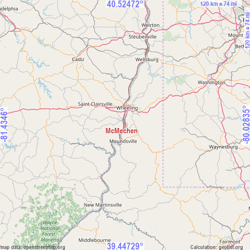
McMechen GPS coordinates[2]
39° 59' 17.268" North, 80° 43' 53.292" West
| Map corner | latitude | longitude |
|---|---|---|
| Upper-left | 40.52472°, | -81.4346° |
| Center: | 39.98813°, | -80.73147° |
| Lower-right: | 39.44729°, | -80.02835° |
| Map W x H: | 119.8×119.8 km | = 74.4×74.4mi |
| max Lat: | 71.29058° ⇑46.5% North |
| McMechen: | 39.98813° |
| min Lat: | ⇓53.5% South 19.06759° |
| min Long | McMechen | max Long |
| -171.73463° | -80.73147° | -66.98998° |
| W 70.2%⇐ | ⇒29.8% E |
Elevation
Elevation of McMechen is 207 m = 679 ft, and this is 87.8 m = 288 ft below average elevation for this country.
| Max E: |
3189 m = 10463 ft | 47.8% |
| Avg. | 294.8 m = 967 ft | |
| McMechen | 207 m = 679 ft | |
Min E: |
-60 m = -197 ft | 52.2% |
See also: United States elevation on elevation.city.
Geographical zone
McMechen is located in North temperate zone (between Tropic of Cancer and the Arctic Circle). Distance of this Northern Tropic circle is 1840.3 km =1143.5 mi to South.| Distance of | km | miles | from McMechen |
|---|---|---|---|
| North Pole | 5560.8 | 3455.3 | to North |
| Arctic Circle | 2954.9 | 1836.1 | to North |
| Tropic Cancer | 1840.3 | 1143.5 | to South |
| Equator | 4446.3 | 2762.8 | to South |


Nearby cities:
15 places around McMechen: (largest is in red/bold)
• Bellaire
3.3 km =2.1 mi,  343°
343°
• Benwood
3.3 km =2.1 mi,  355°
355°
• Bethlehem
7.1 km =4.4 mi,  29°
29°
• Bridgeport
9.1 km =5.7 mi, 355°
• Brookside
9.5 km =5.9 mi, 344°
• Glendale
4.7 km =2.9 mi,  204°
204°
• Lansing
10.9 km =6.8 mi,  332°
332°
• Martins Ferry
12 km =7.5 mi,  2°
2°
• Moundsville
7.6 km =4.7 mi,  187°
187°
• Neffs
8.3 km =5.2 mi,  301°
301°
• Powhatan Point
15.9 km =9.9 mi,  206°
206°
• Shadyside
2.5 km =1.6 mi,  220°
220°
• Triadelphia
11.3 km =7 mi,  50°
50°
• Wheeling
8.5 km =5.3 mi,  6°
6°
• Wolfhurst
10.1 km =6.3 mi, 333°
Sources, notices
• [Note1] Compared only with cities in United States existing in our database
• [Src1] Map data: © OpenStreetMap contributors (CC-BY-SA)
• [Src2] Other city data from geonames.org with taken over terms of usage.
• [Src3] Geographical zone / Annual Mean Temperature by Robert A. Rohde @ Wikipedia
