Anamosa geodata
Anamosa (Iowa) is a seat of a second-order administrative division; located in United States in America/Chicago (GMT-5) time zone. With population of 5,469 people, there are 6789 cities with bigger population in this country. Compared to other cities in United States, 76.6% of cities are located further ↓South; 62.7% of cities are located further →East and 63.9% of cities have lower elevation than Anamosa. Note1


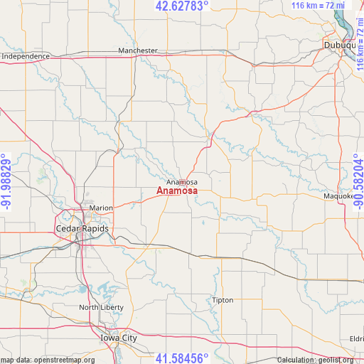
Anamosa GPS coordinates[2]
42° 6' 30.024" North, 91° 17' 6.576" West
| Map corner | latitude | longitude |
|---|---|---|
| Upper-left | 42.62783°, | -91.98829° |
| Center: | 42.10834°, | -91.28516° |
| Lower-right: | 41.58456°, | -90.58204° |
| Map W x H: | 116×116 km | = 72.1×72.1mi |
| max Lat: | 71.29058° ⇑23.4% North |
| Anamosa: | 42.10834° |
| min Lat: | ⇓76.6% South 19.06759° |
| min Long | Anamosa | max Long |
| -171.73463° | -91.28516° | -66.98998° |
| W 37.3%⇐ | ⇒62.7% E |
Elevation
Elevation of Anamosa is 257 m = 843 ft, and this is 37.8 m = 124 ft below average elevation for this country.
| Max E: |
3189 m = 10463 ft | 36.1% |
| Avg. | 294.8 m = 967 ft | |
| Anamosa | 257 m = 843 ft | |
Min E: |
-60 m = -197 ft | 63.9% |
See also: United States elevation on elevation.city.
Geographical zone
Anamosa is located in North temperate zone (between Tropic of Cancer and the Arctic Circle). Distance of this Northern Tropic circle is 2076.1 km =1290 mi to South.| Distance of | km | miles | from Anamosa |
|---|---|---|---|
| North Pole | 5325.1 | 3308.9 | to North |
| Arctic Circle | 2719.2 | 1689.6 | to North |
| Tropic Cancer | 2076.1 | 1290 | to South |
| Equator | 4682 | 2909.3 | to South |


Nearby cities:
15 places around Anamosa: (largest is in red/bold)
• Alburnett
27.8 km =17.3 mi,  279°
279°
• Cascade
30.7 km =19.1 mi,  46°
46°
• Central City
22.4 km =13.9 mi,  298°
298°
• Clarence
30.9 km =19.2 mi,  142°
142°
• Coggon
27.9 km =17.3 mi,  313°
313°
• Hopkinton
26.4 km =16.4 mi,  6°
6°
• Lisbon
22.4 km =13.9 mi,  201°
201°
• Marion
27.1 km =16.8 mi,  252°
252°
• Mechanicsville
22.8 km =14.2 mi,  173°
173°
• Monticello
16.6 km =10.3 mi,  29°
29°
• Mount Vernon
23.4 km =14.5 mi,  207°
207°
• Olin
17.1 km =10.6 mi, 135°
• Springville
14.1 km =8.8 mi, 247°
• Stanwood
26.4 km =16.4 mi,  155°
155°
• Wyoming
23.6 km =14.7 mi,  103°
103°
Sources, notices
• [Note1] Compared only with cities in United States existing in our database
• [Src1] Map data: © OpenStreetMap contributors (CC-BY-SA)
• [Src2] Other city data from geonames.org with taken over terms of usage.
• [Src3] Geographical zone / Annual Mean Temperature by Robert A. Rohde @ Wikipedia
