Cherokee geodata
Cherokee (Iowa) is a seat of a second-order administrative division; located in United States in America/Chicago (GMT-5) time zone. With population of 5,030 people, there are 7143 cities with bigger population in this country. Compared to other cities in United States, 81.6% of cities are located further ↓South; 72.5% of cities are located further →East and 80.7% of cities have lower elevation than Cherokee. Note1


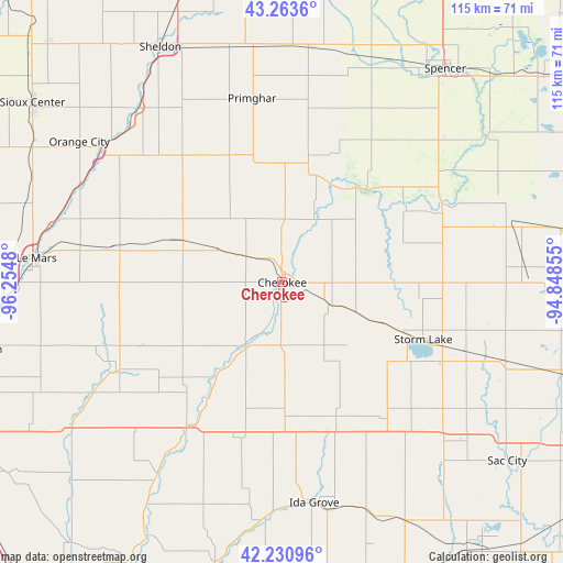
Cherokee GPS coordinates[2]
42° 44' 57.948" North, 95° 33' 6.012" West
| Map corner | latitude | longitude |
|---|---|---|
| Upper-left | 43.2636°, | -96.2548° |
| Center: | 42.74943°, | -95.55167° |
| Lower-right: | 42.23096°, | -94.84855° |
| Map W x H: | 114.8×114.8 km | = 71.3×71.3mi |
| max Lat: | 71.29058° ⇑18.4% North |
| Cherokee: | 42.74943° |
| min Lat: | ⇓81.6% South 19.06759° |
| min Long | Cherokee | max Long |
| -171.73463° | -95.55167° | -66.98998° |
| W 27.5%⇐ | ⇒72.5% E |
Elevation
Elevation of Cherokee is 361 m = 1184 ft, and this is 66.2 m = 217 ft above average elevation for this country.
| Max E: |
3189 m = 10463 ft | 19.3% |
| Cherokee | 361 m 1184 ft | |
| Avg. | 294.8 m = 967 ft | |
Min E: |
-60 m = -197 ft | 80.7% |
See also: United States elevation on elevation.city.
Geographical zone
Cherokee is located in North temperate zone (between Tropic of Cancer and the Arctic Circle). Distance of this Northern Tropic circle is 2147.4 km =1334.3 mi to South.| Distance of | km | miles | from Cherokee |
|---|---|---|---|
| North Pole | 5253.8 | 3264.6 | to North |
| Arctic Circle | 2647.9 | 1645.3 | to North |
| Tropic Cancer | 2147.4 | 1334.3 | to South |
| Equator | 4753.3 | 2953.6 | to South |


Nearby cities:
15 places around Cherokee: (largest is in red/bold)
• Alta
22.9 km =14.2 mi,  111°
111°
• Aurelia
10.2 km =6.3 mi, 113°
• Correctionville
36 km =22.4 mi,  212°
212°
• Holstein
28.9 km =18 mi,  178°
178°
• Ida Grove
45.4 km =28.2 mi,  171°
171°
• Kingsley
38.4 km =23.9 mi,  242°
242°
• Lakeside
34 km =21.1 mi, 114°
• Marcus
22.5 km =14 mi,  292°
292°
• Paullina
27.9 km =17.3 mi,  336°
336°
• Primghar
38 km =23.6 mi,  350°
350°
• Remsen
35.2 km =21.9 mi,  281°
281°
• Schaller
34.9 km =21.7 mi,  142°
142°
• Sioux Rapids
36.4 km =22.6 mi,  63°
63°
• Storm Lake
30.4 km =18.9 mi, 113°
• Sutherland
25.4 km =15.8 mi,  10°
10°
Sources, notices
• [Note1] Compared only with cities in United States existing in our database
• [Src1] Map data: © OpenStreetMap contributors (CC-BY-SA)
• [Src2] Other city data from geonames.org with taken over terms of usage.
• [Src3] Geographical zone / Annual Mean Temperature by Robert A. Rohde @ Wikipedia
