Humboldt geodata
Humboldt (Iowa) is a populated place; located in United States in America/Chicago (GMT-5) time zone. With population of 4,596 people, there are 7547 cities with bigger population in this country. Compared to other cities in United States, 81.4% of cities are located further ↓South; 69.1% of cities are located further →East and 77.4% of cities have lower elevation than Humboldt. Note1


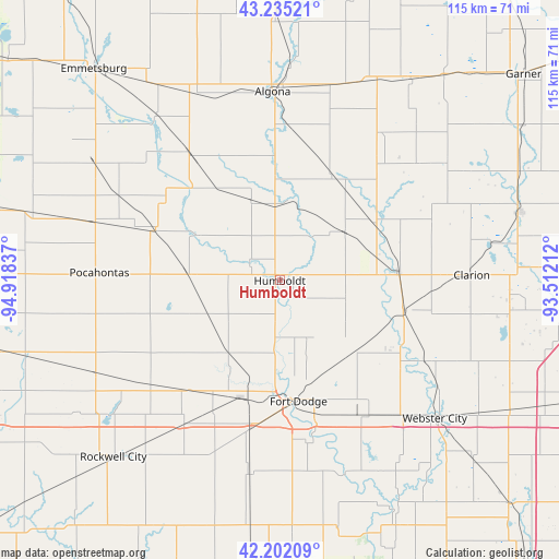
Humboldt GPS coordinates[2]
42° 43' 14.88" North, 94° 12' 54.864" West
| Map corner | latitude | longitude |
|---|---|---|
| Upper-left | 43.23521°, | -94.91837° |
| Center: | 42.7208°, | -94.21524° |
| Lower-right: | 42.20209°, | -93.51212° |
| Map W x H: | 114.9×114.9 km | = 71.4×71.4mi |
| max Lat: | 71.29058° ⇑18.6% North |
| Humboldt: | 42.7208° |
| min Lat: | ⇓81.4% South 19.06759° |
| min Long | Humboldt | max Long |
| -171.73463° | -94.21524° | -66.98998° |
| W 30.9%⇐ | ⇒69.1% E |
Elevation
Elevation of Humboldt is 331 m = 1086 ft, and this is 36.2 m = 119 ft above average elevation for this country.
| Max E: |
3189 m = 10463 ft | 22.6% |
| Humboldt | 331 m 1086 ft | |
| Avg. | 294.8 m = 967 ft | |
Min E: |
-60 m = -197 ft | 77.4% |
See also: United States elevation on elevation.city.
Geographical zone
Humboldt is located in North temperate zone (between Tropic of Cancer and the Arctic Circle). Distance of this Northern Tropic circle is 2144.2 km =1332.3 mi to South.| Distance of | km | miles | from Humboldt |
|---|---|---|---|
| North Pole | 5257 | 3266.5 | to North |
| Arctic Circle | 2651.1 | 1647.3 | to North |
| Tropic Cancer | 2144.2 | 1332.3 | to South |
| Equator | 4750.1 | 2951.6 | to South |


Nearby cities:
15 places around Humboldt: (largest is in red/bold)
• Algona
38.9 km =24.2 mi,  357°
357°
• Badger
13.1 km =8.1 mi,  154°
154°
• Clarion
39.4 km =24.5 mi,  88°
88°
• Coalville
31.5 km =19.6 mi,  166°
166°
• Dakota City
1.5 km =0.9 mi,  84°
84°
• Eagle Grove
26.2 km =16.3 mi,  103°
103°
• Fort Dodge
25.1 km =15.6 mi, 171°
• Goldfield
24.1 km =15 mi, 86°
• Kanawha
42 km =26.1 mi,  54°
54°
• Manson
33.7 km =20.9 mi,  230°
230°
• Otho
33.4 km =20.8 mi, 170°
• Pocahontas
37.1 km =23.1 mi,  272°
272°
• Pomeroy
42.7 km =26.5 mi,  243°
243°
• Rolfe
27.4 km =17 mi,  291°
291°
• West Bend
32.1 km =19.9 mi,  324°
324°
Sources, notices
• [Note1] Compared only with cities in United States existing in our database
• [Src1] Map data: © OpenStreetMap contributors (CC-BY-SA)
• [Src2] Other city data from geonames.org with taken over terms of usage.
• [Src3] Geographical zone / Annual Mean Temperature by Robert A. Rohde @ Wikipedia
