Iowa Falls geodata
Iowa Falls (Iowa) is a populated place; located in United States in America/Chicago (GMT-5) time zone. With population of 5,195 people, there are 7009 cities with bigger population in this country. Compared to other cities in United States, 79.9% of cities are located further ↓South; 66.9% of cities are located further →East and 78.7% of cities have lower elevation than Iowa Falls. Note1


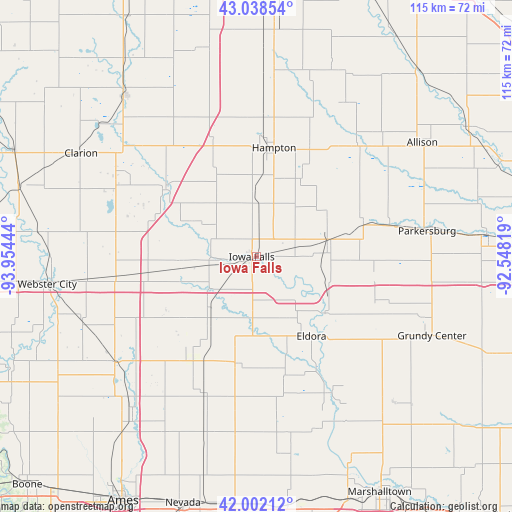
Iowa Falls GPS coordinates[2]
42° 31' 20.928" North, 93° 15' 4.716" West
| Map corner | latitude | longitude |
|---|---|---|
| Upper-left | 43.03854°, | -93.95444° |
| Center: | 42.52248°, | -93.25131° |
| Lower-right: | 42.00212°, | -92.54819° |
| Map W x H: | 115.2×115.2 km | = 71.6×71.6mi |
| max Lat: | 71.29058° ⇑20.1% North |
| Iowa Falls: | 42.52248° |
| min Lat: | ⇓79.9% South 19.06759° |
| min Long | Iowa Falls | max Long |
| -171.73463° | -93.25131° | -66.98998° |
| W 33.1%⇐ | ⇒66.9% E |
Elevation
Elevation of Iowa Falls is 342 m = 1122 ft, and this is 47.2 m = 155 ft above average elevation for this country.
| Max E: |
3189 m = 10463 ft | 21.3% |
| Iowa Falls | 342 m 1122 ft | |
| Avg. | 294.8 m = 967 ft | |
Min E: |
-60 m = -197 ft | 78.7% |
See also: United States elevation on elevation.city.
Geographical zone
Iowa Falls is located in North temperate zone (between Tropic of Cancer and the Arctic Circle). Distance of this Northern Tropic circle is 2122.1 km =1318.6 mi to South.| Distance of | km | miles | from Iowa Falls |
|---|---|---|---|
| North Pole | 5279 | 3280.2 | to North |
| Arctic Circle | 2673.1 | 1661 | to North |
| Tropic Cancer | 2122.1 | 1318.6 | to South |
| Equator | 4728.1 | 2937.9 | to South |


Nearby cities:
15 places around Iowa Falls: (largest is in red/bold)
• Ackley
16.6 km =10.3 mi,  77°
77°
• Alden
10.2 km =6.3 mi,  268°
268°
• Aplington
30.8 km =19.1 mi, 77°
• Dows
25.3 km =15.7 mi,  306°
306°
• Dumont
34.1 km =21.2 mi,  41°
41°
• Eldora
21.9 km =13.6 mi,  145°
145°
• Ellsworth
35.6 km =22.1 mi,  229°
229°
• Hampton
24.7 km =15.3 mi,  9°
9°
• Hubbard
24.5 km =15.2 mi,  189°
189°
• Jewell
39.9 km =24.8 mi, 233°
• Oakland
17 km =10.6 mi,  292°
292°
• Parkersburg
38.5 km =23.9 mi, 80°
• Radcliffe
27.5 km =17.1 mi,  213°
213°
• Wellsburg
26.6 km =16.5 mi,  105°
105°
• Zearing
40.4 km =25.1 mi, 185°
Sources, notices
• [Note1] Compared only with cities in United States existing in our database
• [Src1] Map data: © OpenStreetMap contributors (CC-BY-SA)
• [Src2] Other city data from geonames.org with taken over terms of usage.
• [Src3] Geographical zone / Annual Mean Temperature by Robert A. Rohde @ Wikipedia
