Ashburn geodata
Ashburn (Illinois) is a section of populated place; located in United States in America/Chicago (GMT-5) time zone. With population of 42,752 people, there are 1121 cities with bigger population in this country. Compared to other cities in United States, 73.4% of cities are located further ↓South; 51.5% of cities are located further →East and 52.2% of cities have higher elevation than Ashburn. Note1


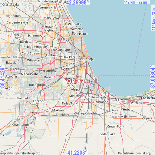
Ashburn GPS coordinates[2]
41° 44' 51.108" North, 87° 42' 40.176" West
| Map corner | latitude | longitude |
|---|---|---|
| Upper-left | 42.26998°, | -88.41429° |
| Center: | 41.74753°, | -87.71116° |
| Lower-right: | 41.2208°, | -87.00804° |
| Map W x H: | 116.7×116.7 km | = 72.5×72.5mi |
| max Lat: | 71.29058° ⇑26.6% North |
| Ashburn: | 41.74753° |
| min Lat: | ⇓73.4% South 19.06759° |
| min Long | Ashburn | max Long |
| -171.73463° | -87.71116° | -66.98998° |
| W 48.5%⇐ | ⇒51.5% E |
Elevation
Elevation of Ashburn is 190 m = 623 ft, and this is 104.8 m = 344 ft below average elevation for this country.
| Max E: |
3189 m = 10463 ft | 52.2% |
| Avg. | 294.8 m = 967 ft | |
| Ashburn | 190 m = 623 ft | |
Min E: |
-60 m = -197 ft | 47.8% |
See also: Ashburn elevation on elevation.city.
Geographical zone
Ashburn is located in North temperate zone (between Tropic of Cancer and the Arctic Circle). Distance of this Northern Tropic circle is 2036 km =1265.1 mi to South.| Distance of | km | miles | from Ashburn |
|---|---|---|---|
| North Pole | 5365.2 | 3333.8 | to North |
| Arctic Circle | 2759.3 | 1714.5 | to North |
| Tropic Cancer | 2036 | 1265.1 | to South |
| Equator | 4641.9 | 2884.3 | to South |


Nearby cities:
15 places around Ashburn: (largest is in red/bold)
• Auburn Gresham
4.8 km =3 mi,  97°
97°
• Burbank
5.9 km =3.7 mi,  255°
255°
• Chicago Lawn
3.3 km =2.1 mi,  21°
21°
• Chicago Ridge
7.6 km =4.7 mi,  227°
227°
• Englewood
6.5 km =4 mi,  56°
56°
• Evergreen Park
3.1 km =1.9 mi,  165°
165°
• Gage Park
5.4 km =3.4 mi,  13°
13°
• Hometown
2.2 km =1.4 mi, 229°
• Merrionette Park
7.1 km =4.4 mi, 172°
• Morgan Park
7.4 km =4.6 mi,  149°
149°
• Mount Greenwood
5.5 km =3.4 mi,  177°
177°
• Oak Lawn
5.6 km =3.5 mi,  223°
223°
• West Elsdon
5.3 km =3.3 mi,  347°
347°
• West Englewood
5 km =3.1 mi,  47°
47°
• West Lawn
3 km =1.9 mi,  341°
341°
Sources, notices
• [Note1] Compared only with cities in United States existing in our database
• [Src1] Map data: © OpenStreetMap contributors (CC-BY-SA)
• [Src2] Other city data from geonames.org with taken over terms of usage.
• [Src3] Geographical zone / Annual Mean Temperature by Robert A. Rohde @ Wikipedia
