Cicero geodata
Cicero (Illinois) is a populated place; located in United States in America/Chicago (GMT-5) time zone. With population of 83,886 people, there are 464 cities with bigger population in this country. Compared to other cities in United States, 74.3% of cities are located further ↓South; 51.7% of cities are located further →East and 53.3% of cities have higher elevation than Cicero. Note1


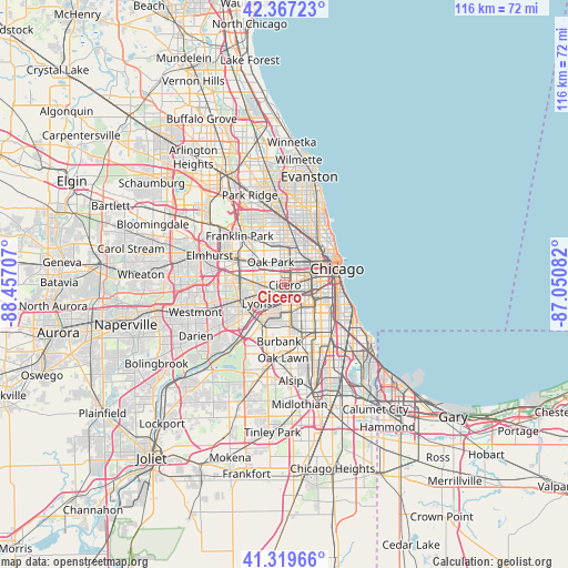
Cicero GPS coordinates[2]
41° 50' 44.124" North, 87° 45' 14.184" West
| Map corner | latitude | longitude |
|---|---|---|
| Upper-left | 42.36723°, | -88.45707° |
| Center: | 41.84559°, | -87.75394° |
| Lower-right: | 41.31966°, | -87.05082° |
| Map W x H: | 116.5×116.5 km | = 72.4×72.4mi |
| max Lat: | 71.29058° ⇑25.7% North |
| Cicero: | 41.84559° |
| min Lat: | ⇓74.3% South 19.06759° |
| min Long | Cicero | max Long |
| -171.73463° | -87.75394° | -66.98998° |
| W 48.3%⇐ | ⇒51.7% E |
Elevation
Elevation of Cicero is 186 m = 610 ft, and this is 108.8 m = 357 ft below average elevation for this country.
| Max E: |
3189 m = 10463 ft | 53.3% |
| Avg. | 294.8 m = 967 ft | |
| Cicero | 186 m = 610 ft | |
Min E: |
-60 m = -197 ft | 46.7% |
See also: Cicero elevation on elevation.city.
Geographical zone
Cicero is located in North temperate zone (between Tropic of Cancer and the Arctic Circle). Distance of this Northern Tropic circle is 2046.9 km =1271.9 mi to South.| Distance of | km | miles | from Cicero |
|---|---|---|---|
| North Pole | 5354.3 | 3327 | to North |
| Arctic Circle | 2748.4 | 1707.8 | to North |
| Tropic Cancer | 2046.9 | 1271.9 | to South |
| Equator | 4652.8 | 2891.1 | to South |


Nearby cities:
15 places around Cicero: (largest is in red/bold)
• Berwyn
3.3 km =2.1 mi,  279°
279°
• Brighton Park
5.4 km =3.4 mi,  123°
123°
• East Garfield Park
5.8 km =3.6 mi,  47°
47°
• Forest Park
6.2 km =3.9 mi,  307°
307°
• Forest View
5.3 km =3.3 mi,  218°
218°
• Lyons
6.4 km =4 mi,  236°
236°
• McKinley Park
6.8 km =4.2 mi,  103°
103°
• North Lawndale
3.4 km =2.1 mi,  61°
61°
• North Riverside
5.7 km =3.5 mi,  266°
266°
• Oak Park
5.1 km =3.2 mi,  330°
330°
• Riverside
5.8 km =3.6 mi,  258°
258°
• South Lawndale
3.4 km =2.1 mi,  93°
93°
• Stickney
3.6 km =2.2 mi, 221°
• West Elsdon
6.2 km =3.9 mi,  156°
156°
• West Garfield Park
4.4 km =2.7 mi,  27°
27°
Sources, notices
• [Note1] Compared only with cities in United States existing in our database
• [Src1] Map data: © OpenStreetMap contributors (CC-BY-SA)
• [Src2] Other city data from geonames.org with taken over terms of usage.
• [Src3] Geographical zone / Annual Mean Temperature by Robert A. Rohde @ Wikipedia
