Franklin Grove geodata
Franklin Grove (Illinois) is a populated place; located in United States in America/Chicago (GMT-5) time zone. With population of 967 people, there are 16516 cities with bigger population in this country. Compared to other cities in United States, 74.3% of cities are located further ↓South; 57% of cities are located further →East and 62.6% of cities have lower elevation than Franklin Grove. Note1
Administrative division(s):
- Level 1: Illinois
- Level 2: Lee County
- Level 3: Township of Franklin Grove


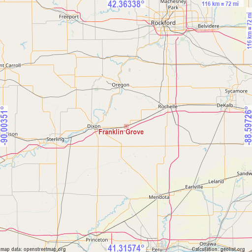
Franklin Grove GPS coordinates[2]
41° 50' 30.12" North, 89° 18' 1.368" West
| Map corner | latitude | longitude |
|---|---|---|
| Upper-left | 42.36338°, | -90.00351° |
| Center: | 41.8417°, | -89.30038° |
| Lower-right: | 41.31574°, | -88.59726° |
| Map W x H: | 116.5×116.5 km | = 72.4×72.4mi |
| max Lat: | 71.29058° ⇑25.7% North |
| Franklin Grove: | 41.8417° |
| min Lat: | ⇓74.3% South 19.06759° |
| min Long | Franklin Grove | max Long |
| -171.73463° | -89.30038° | -66.98998° |
| W 43%⇐ | ⇒57% E |
Elevation
Elevation of Franklin Grove is 251 m = 823 ft, and this is 43.8 m = 144 ft below average elevation for this country.
| Max E: |
3189 m = 10463 ft | 37.4% |
| Avg. | 294.8 m = 967 ft | |
| Franklin Grove | 251 m = 823 ft | |
Min E: |
-60 m = -197 ft | 62.6% |
See also: United States elevation on elevation.city.
Geographical zone
Franklin Grove is located in North temperate zone (between Tropic of Cancer and the Arctic Circle). Distance of this Northern Tropic circle is 2046.4 km =1271.6 mi to South.| Distance of | km | miles | from Franklin Grove |
|---|---|---|---|
| North Pole | 5354.7 | 3327.3 | to North |
| Arctic Circle | 2748.8 | 1708 | to North |
| Tropic Cancer | 2046.4 | 1271.6 | to South |
| Equator | 4652.4 | 2890.9 | to South |


Nearby cities:
15 places around Franklin Grove: (largest is in red/bold)
• Amboy
14.4 km =8.9 mi,  189°
189°
• Ashton
7.1 km =4.4 mi,  67°
67°
• Byron
31.9 km =19.8 mi,  6°
6°
• Carthage
8.7 km =5.4 mi,  352°
352°
• Creston
29.5 km =18.3 mi, 70°
• Dixon
14.8 km =9.2 mi,  268°
268°
• Hillcrest
23 km =14.3 mi,  58°
58°
• Lost Nation
9.5 km =5.9 mi,  324°
324°
• Mount Morris
25.6 km =15.9 mi,  334°
334°
• Oregon
19.4 km =12.1 mi, 352°
• Palmyra
23 km =14.3 mi, 272°
• Paw Paw
31.5 km =19.6 mi,  122°
122°
• Polo
28.1 km =17.5 mi,  304°
304°
• Rochelle
21.2 km =13.2 mi, 64°
• Stillman Valley
31.2 km =19.4 mi,  18°
18°
Sources, notices
• [Note1] Compared only with cities in United States existing in our database
• [Src1] Map data: © OpenStreetMap contributors (CC-BY-SA)
• [Src2] Other city data from geonames.org with taken over terms of usage.
• [Src3] Geographical zone / Annual Mean Temperature by Robert A. Rohde @ Wikipedia
