Kankakee geodata
Kankakee (Illinois) is a seat of a second-order administrative division; located in United States in America/Chicago (GMT-5) time zone. With population of 26,676 people, there are 1877 cities with bigger population in this country. Compared to other cities in United States, 67% of cities are located further ↓South; 52.2% of cities are located further →East and 51.9% of cities have lower elevation than Kankakee. Note1
Administrative division(s):
- Level 1: Illinois
- Level 2: Kankakee County
- Level 3: Township of Kankakee


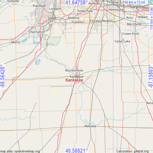
Kankakee GPS coordinates[2]
41° 7' 12.108" North, 87° 51' 40.14" West
| Map corner | latitude | longitude |
|---|---|---|
| Upper-left | 41.64758°, | -88.56428° |
| Center: | 41.12003°, | -87.86115° |
| Lower-right: | 40.58821°, | -87.15803° |
| Map W x H: | 117.8×117.8 km | = 73.2×73.2mi |
| max Lat: | 71.29058° ⇑33% North |
| Kankakee: | 41.12003° |
| min Lat: | ⇓67% South 19.06759° |
| min Long | Kankakee | max Long |
| -171.73463° | -87.86115° | -66.98998° |
| W 47.8%⇐ | ⇒52.2% E |
Elevation
Elevation of Kankakee is 206 m = 676 ft, and this is 88.8 m = 291 ft below average elevation for this country.
| Max E: |
3189 m = 10463 ft | 48.1% |
| Avg. | 294.8 m = 967 ft | |
| Kankakee | 206 m = 676 ft | |
Min E: |
-60 m = -197 ft | 51.9% |
See also: United States elevation on elevation.city.
Geographical zone
Kankakee is located in North temperate zone (between Tropic of Cancer and the Arctic Circle). Distance of this Northern Tropic circle is 1966.2 km =1221.7 mi to South.| Distance of | km | miles | from Kankakee |
|---|---|---|---|
| North Pole | 5434.9 | 3377.1 | to North |
| Arctic Circle | 2829.1 | 1757.9 | to North |
| Tropic Cancer | 1966.2 | 1221.7 | to South |
| Equator | 4572.1 | 2841 | to South |


Nearby cities:
15 places around Kankakee: (largest is in red/bold)
• Aroma Park
6.1 km =3.8 mi,  137°
137°
• Ashkum
27.8 km =17.3 mi,  196°
196°
• Bourbonnais
4.4 km =2.7 mi,  329°
329°
• Bradley
2.4 km =1.5 mi,  0°
0°
• Chebanse
13.6 km =8.5 mi, 196°
• Clifton
21.4 km =13.3 mi, 196°
• Grant Park
22.5 km =14 mi,  53°
53°
• Herscher
21.3 km =13.2 mi,  248°
248°
• Hopkins Park
20.8 km =12.9 mi,  107°
107°
• Limestone
9.1 km =5.7 mi,  278°
278°
• Manteno
14.7 km =9.1 mi,  9°
9°
• Momence
17.4 km =10.8 mi,  72°
72°
• Peotone
24.4 km =15.2 mi,  15°
15°
• Saint Anne
16.2 km =10.1 mi,  130°
130°
• Sun River Terrace
10.5 km =6.5 mi,  85°
85°
Sources, notices
• [Note1] Compared only with cities in United States existing in our database
• [Src1] Map data: © OpenStreetMap contributors (CC-BY-SA)
• [Src2] Other city data from geonames.org with taken over terms of usage.
• [Src3] Geographical zone / Annual Mean Temperature by Robert A. Rohde @ Wikipedia
