Lakemoor geodata
Lakemoor (Illinois) is a populated place; located in United States in America/Chicago (GMT-5) time zone. With population of 6,015 people, there are 6395 cities with bigger population in this country. Compared to other cities in United States, 78.4% of cities are located further ↓South; 53.7% of cities are located further →East and 58.6% of cities have lower elevation than Lakemoor. Note1


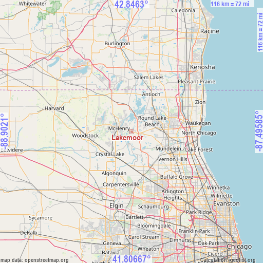
Lakemoor GPS coordinates[2]
42° 19' 43.068" North, 88° 11' 56.292" West
| Map corner | latitude | longitude |
|---|---|---|
| Upper-left | 42.8463°, | -88.9021° |
| Center: | 42.32863°, | -88.19897° |
| Lower-right: | 41.80667°, | -87.49585° |
| Map W x H: | 115.6×115.6 km | = 71.8×71.8mi |
| max Lat: | 71.29058° ⇑21.6% North |
| Lakemoor: | 42.32863° |
| min Lat: | ⇓78.4% South 19.06759° |
| min Long | Lakemoor | max Long |
| -171.73463° | -88.19897° | -66.98998° |
| W 46.3%⇐ | ⇒53.7% E |
Elevation
Elevation of Lakemoor is 233 m = 764 ft, and this is 61.8 m = 203 ft below average elevation for this country.
| Max E: |
3189 m = 10463 ft | 41.4% |
| Avg. | 294.8 m = 967 ft | |
| Lakemoor | 233 m = 764 ft | |
Min E: |
-60 m = -197 ft | 58.6% |
See also: United States elevation on elevation.city.
Geographical zone
Lakemoor is located in North temperate zone (between Tropic of Cancer and the Arctic Circle). Distance of this Northern Tropic circle is 2100.6 km =1305.3 mi to South.| Distance of | km | miles | from Lakemoor |
|---|---|---|---|
| North Pole | 5300.6 | 3293.6 | to North |
| Arctic Circle | 2694.7 | 1674.4 | to North |
| Tropic Cancer | 2100.6 | 1305.3 | to South |
| Equator | 4706.5 | 2924.5 | to South |


Nearby cities:
15 places around Lakemoor: (largest is in red/bold)
• Fox Lake
7.7 km =4.8 mi,  9°
9°
• Holiday Hills
4.8 km =3 mi,  206°
206°
• Island Lake
5.9 km =3.7 mi,  174°
174°
• Johnsburg
6.7 km =4.2 mi,  328°
328°
• Long Lake
7.5 km =4.7 mi,  51°
51°
• McCullom Lake
8.9 km =5.5 mi,  299°
299°
• McHenry
5.6 km =3.5 mi,  275°
275°
• Oakwood Hills
9.8 km =6.1 mi,  201°
201°
• Pistakee Highlands
8.9 km =5.5 mi,  356°
356°
• Port Barrington
9.6 km =6 mi,  181°
181°
• Prairie Grove
7.5 km =4.7 mi,  222°
222°
• Round Lake
9.1 km =5.7 mi,  72°
72°
• Round Lake Heights
9.7 km =6 mi, 53°
• Volo
2.6 km =1.6 mi,  96°
96°
• Wauconda
9.2 km =5.7 mi,  147°
147°
Sources, notices
• [Note1] Compared only with cities in United States existing in our database
• [Src1] Map data: © OpenStreetMap contributors (CC-BY-SA)
• [Src2] Other city data from geonames.org with taken over terms of usage.
• [Src3] Geographical zone / Annual Mean Temperature by Robert A. Rohde @ Wikipedia
