Mettawa geodata
Mettawa (Illinois) is a populated place; located in United States in America/Chicago (GMT-5) time zone. With population of 578 people, there are 19937 cities with bigger population in this country. Compared to other cities in United States, 77.6% of cities are located further ↓South; 52.5% of cities are located further →East and 53.9% of cities have lower elevation than Mettawa. Note1


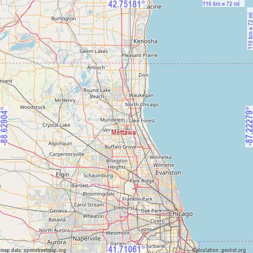
Mettawa GPS coordinates[2]
42° 14' 0.096" North, 87° 55' 33.276" West
| Map corner | latitude | longitude |
|---|---|---|
| Upper-left | 42.75181°, | -88.62904° |
| Center: | 42.23336°, | -87.92591° |
| Lower-right: | 41.71061°, | -87.22279° |
| Map W x H: | 115.8×115.8 km | = 72×72mi |
| max Lat: | 71.29058° ⇑22.4% North |
| Mettawa: | 42.23336° |
| min Lat: | ⇓77.6% South 19.06759° |
| min Long | Mettawa | max Long |
| -171.73463° | -87.92591° | -66.98998° |
| W 47.5%⇐ | ⇒52.5% E |
Elevation
Elevation of Mettawa is 214 m = 702 ft, and this is 80.8 m = 265 ft below average elevation for this country.
| Max E: |
3189 m = 10463 ft | 46.1% |
| Avg. | 294.8 m = 967 ft | |
| Mettawa | 214 m = 702 ft | |
Min E: |
-60 m = -197 ft | 53.9% |
See also: United States elevation on elevation.city.
Geographical zone
Mettawa is located in North temperate zone (between Tropic of Cancer and the Arctic Circle). Distance of this Northern Tropic circle is 2090 km =1298.7 mi to South.| Distance of | km | miles | from Mettawa |
|---|---|---|---|
| North Pole | 5311.2 | 3300.2 | to North |
| Arctic Circle | 2705.3 | 1681 | to North |
| Tropic Cancer | 2090 | 1298.7 | to South |
| Equator | 4695.9 | 2917.9 | to South |


Nearby cities:
15 places around Mettawa: (largest is in red/bold)
• Bannockburn
6.6 km =4.1 mi,  132°
132°
• Buffalo Grove
9.5 km =5.9 mi,  197°
197°
• Deerfield
9.6 km =6 mi,  135°
135°
• Green Oaks
6.6 km =4.1 mi,  16°
16°
• Highwood
10.3 km =6.4 mi,  111°
111°
• Indian Creek
4.5 km =2.8 mi,  260°
260°
• Knollwood
6.7 km =4.2 mi,  29°
29°
• Lake Bluff
9.1 km =5.7 mi,  56°
56°
• Lake Forest
7.6 km =4.7 mi,  68°
68°
• Libertyville
6 km =3.7 mi,  337°
337°
• Lincolnshire
5 km =3.1 mi,  163°
163°
• Long Grove
8.5 km =5.3 mi,  224°
224°
• Mundelein
7.2 km =4.5 mi,  297°
297°
• Riverwoods
7.7 km =4.8 mi, 161°
• Vernon Hills
4.7 km =2.9 mi,  250°
250°
Sources, notices
• [Note1] Compared only with cities in United States existing in our database
• [Src1] Map data: © OpenStreetMap contributors (CC-BY-SA)
• [Src2] Other city data from geonames.org with taken over terms of usage.
• [Src3] Geographical zone / Annual Mean Temperature by Robert A. Rohde @ Wikipedia
